1990s Maps of Sitka, Alaska
Explore 16 historic maps of Sitka from the 1990s. These maps offer a rare glimpse into what life looked like during the 1990s — showing old roads, neighborhoods, homes, and landmarks that have changed or disappeared over time.
Whether you're researching your family's past, planning a metal detecting trip, or studying how Sitka's landscape evolved across the 1990s, these high-resolution maps are a powerful tool for exploring the history of this region.
- Focus on a specific era: All maps on this page are from the 1990s, giving you a focused view of this time period.
- See what’s changed: Compare century-old streets, trails, and buildings to today's modern landscape using overlays and satellite layers.
- Research with precision: Use these maps for genealogy, historical research, land use analysis, or educational projects.
- View, download, or print: Maps are fully viewable online in high resolution, and can be downloaded or printed for your own records.
Start exploring Sitka's history through authentic maps from the 1990s. This is your window into the past.
Sitka, AK maps
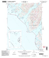
(16)- 1994 Map of Sitka C-7, 1998 Print
 1994 Sitka C-71998 Print · USGSThe West Chichagof coast and its deep-water inlets are captured here in the mid-nineties, showing the intersection of wilderness and historic mining activity. Genealogists and historians can locate the settlement of Chichagof, identify Ruins along the coast, and trace the intricate channels of Ogden Passage.
 - 1994 Map of Port Alexander C-3, 1998 Print
 1994 Port Alexander C-31998 Print · USGSBaranof Island's remote fjords and mountain cabins are captured in the mid-nineties as the wilderness remained a vital hub for conservation and recreation. Researchers can trace the Davidof Trail or locate isolated outposts like the Avoss Lake Cabin (FS) and the Fish Hatchery.2 unique versions available
 - 1994 Map of Port Alexander C-4, 1998 Print
 1994 Port Alexander C-41998 Print · USGSBaranof Island's wild western coastline remains untouched by roads in the 1990s, defined by the vast Tongass National Forest. Trace the intricate channels and inlets used by mariners, from Whale Bay and Still Harbor to the scattered Rakof Islands.3 unique versions available
 - 1995 Map of Port Alexander D-3, 1999 Print
 1995 Port Alexander D-31999 Print · USGSSoutheast Alaska in the mid-1990s remained a frontier of deep fjords and glacial lakes where industrial history was already fading into the landscape. Researchers can locate the Cannery (Site) near Red Bluff Bay or trace the drainage from Benzeman Lake.
 - 1995 Map of Sitka D-8, 1999 Print
 1995 Sitka D-81999 Print · USGSThe intricate shoreline of Southeast Alaska is captured here in the mid-1990s, centering on the wilderness of Yakobi Island. Researchers can find remote coastal features like White Sulphur Springs, the Lighthouse Reserve, and the Greentop Cabin (FS) Boat Docks.
 - 1995 Map of Port Alexander D-2, 1999 Print
 1995 Port Alexander D-21999 Print · USGSKuiu and Baranof Islands are mapped in the mid-nineties, showing the rugged intersection of Chatham Strait and Frederick Sound. Researchers can trace remote landmarks like the Lighthouse Reserve and Security Bay State Marine Park.
 - 1996 Map of Sitka A-5, 1999 Print
 1996 Sitka A-51999 Print · USGSThe maritime reaches of Southeast Alaska are charted in the late nineties as Sitka's history of industry and defense gives way to recreation. Trace the remnants of an Army Camp or locate coastal landmarks like Old Sitka State Historic Park and the Vitskari Island Light.
 - 1996 Map of Sitka B-6, 2000 Print
 1996 Sitka B-62000 Print · USGSThe Alexander Archipelago in the 1990s shows a landscape of remote maritime outposts and protected wilderness. Researchers can trace the ruins of Cobol, locate the Lake Shore Cabin, and find navigation aids like the Klokachef Light.
 - 1996 Map of Sitka A-3, 2000 Print
 1996 Sitka A-32000 Print · USGSBaranof Island and the Chatham Strait coastline are captured here in the mid-1990s, showing a landscape of alpine peaks and isolated coastal stations. Researchers can locate the Fish Hatchery (State) near Hidden Falls and trace the remote settlement at Manleyville.
 - 1996 Map of Sitka B-5, 2000 Print
 1996 Sitka B-52000 Print · USGSThe Alexander Archipelago in the mid-1990s showcases a maritime landscape defined by the Alaska Marine Highway and protected wilderness. Trace remote landmarks like the Highwater Island Cabin, Lighthouse Reserve, and timber industry sites at Fish Bay.
 - 1997 Map of Sitka D-3, 2000 Print
 1997 Sitka D-32000 Print · USGSThe coastal waters of Southeast Alaska are captured here in the late nineties, documenting the intersections of Chichagof and Admiralty Islands. Researchers can trace historic industrial sites like Gypsum (Aband) and a Logging Camp near Cube Cove.
 - 1997 Map of Sitka D-7, 2000 Print
 1997 Sitka D-72000 Print · USGSChichagof Island in the late nineties is a landscape of maritime commerce and deep-forest mining. Genealogists and historians can trace the foundations of Pelican, locate the Apex Mine and El Nido Mine, and follow the remote White Sulpher Springs Trail.
 - 1997 Map of Sitka C-3, 2000 Print
 1997 Sitka C-32000 Print · USGSCoastal life on Chichagof and Admiralty Islands is documented here in the late nineties, from remote settlements to wilderness boundaries. Researchers can trace the Sitkoh Lake Trail and locate sites like Chatham, Sitkoh, and the Fish Ladder.
 - 1997 Map of Sitka D-4, 2000 Print
 1997 Sitka D-42000 Print · USGSSoutheast Alaska in the late nineties is defined here by the maritime and timber outposts of Chichagof Island. Researchers can trace the legacy of coastal industry through the Cannery Ruins, the isolated Logging Camp, and remote markers like Tenakee Light.
 - 1997 Map of Sitka B-3, 2000 Print
 1997 Sitka B-32000 Print · USGSThe maritime crossroads of Southeast Alaska are captured in the late nineties, where the Alaska Marine Highway threads through Peril Strait. Genealogists and historians can locate isolated Cabins and coastal Ruins along the shores of Catherine Island and Chichagof Island.
 - 1997 Map of Sitka D-5, 2000 Print
 1997 Sitka D-52000 Print · USGSChichagof Island in the late 1990s reveals a landscape of protected forest management and deep coastal fjords. Trace wilderness infrastructure and maritime landmarks like Salt Lake Bay Cabin(FS), Saltery Bay, and The Narrows.
End of results
Showing maps 1-16 of 16
Top cities of Sitka
Frequently asked questions
- What are the different types of historical maps available for Sitka?
- What is the oldest map of Sitka?
- Where can I purchase historical maps of Sitka for my home or office?
- Where can I download high-res historical maps of Sitka?
- Are there historical topographic maps available for Sitka?
- Is there historical aerial imagery available for Sitka?
- Where are historical maps of Sitka sourced from?