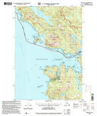
1996 Map of Sitka B-6
USGS Topo · Published 2000About this map
Chichagof Island and Kruzof Island define this coastal reach of the Tongass National Forest during the mid-1990s. The map documents the remnants of industrial or maritime activity at Cobol (Ruins) and other unidentified Ruins along the eastern shore of Kalinin Bay. This maritime landscape is shaped by the complex intersection of Slocum Arm and Salisbury Sound, where navigation is aided by the Klokachef Light and a designated Lighthouse Reserve. Inland, the map captures a period of federal land management indicated by the Lake Shore Cabin (FS) and a Radio Repeater (FS) on Kruzof Island. The Alaska Marine Highway serves as the primary transit corridor through Neva Strait, connecting these islands where the Wilderness Boundary protects the western reaches of the Khaz Peninsula.
Find a feature on this map
66 named features on this map. Tap any name to fly to it.
Don’t see what you’re looking for? This feature index may not catch every label — zoom into the map to look around manually.
Map Details
Editions of this 1996 Sitka B-6 Map
This is the sole edition of this map. No revisions or reprints were ever made.
Other maps of this area

1948 · Sitka A-5
USGS Topo · 1:63,360

1948 · Sitka C-7
USGS Topo · 1:63,360

1948 · Sitka C-6
USGS Topo · 1:63,360

1948 · Sitka B-5
USGS Topo · 1:63,360

1951 · Sitka C-5
USGS Topo · 1:63,360

1951 · Sitka A-6
USGS Topo · 1:63,360

1951 · Sitka B-6
USGS Topo · 1:63,360

1951 · Sitka B-5
USGS Topo · 1:63,360

1951 · Sitka
USGS Topo · 1:250,000

1951 · Sitka C-6
USGS Topo · 1:63,360