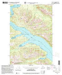
1997 Map of Sitka D-5
USGS Topo · Published 2000About this map
Chichagof Island and the expansive Tenakee Inlet dominate this coastal landscape within the Tongass National Forest. The geography is defined by a intricate system of fjords and bays, including Long Bay, Seal Bay, and Saltery Bay. This 1990s revision by the USDA Forest Service highlights the management boundaries of the Hoonah-Sitka Ranger District and specialized conservation zones like the Lisianski River/Upper Hoonah Sound LUD II Management Area.
Find a feature on this map
21 named features on this map. Tap any name to fly to it.
Don’t see what you’re looking for? This feature index may not catch every label — zoom into the map to look around manually.
Map Details
Editions of this 1997 Sitka D-5 Map
This is the sole edition of this map. No revisions or reprints were ever made.
Other maps of this area

1948 · Juneau A-4
USGS Topo · 1:63,360

1948 · Sitka D-5
USGS Topo · 1:63,360

1948 · Sitka D-4
USGS Topo · 1:63,360

1948 · Sitka C-6
USGS Topo · 1:63,360

1948 · Sitka D-6
USGS Topo · 1:63,360

1951 · Juneau
USGS Topo · 1:250,000

1951 · Juneau A-6
USGS Topo · 1:63,360

1951 · Juneau A-5
USGS Topo · 1:63,360

1951 · Sitka C-5
USGS Topo · 1:63,360

1951 · Sitka C-4
USGS Topo · 1:63,360