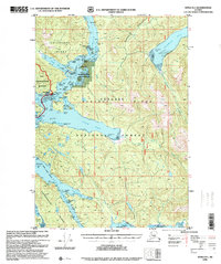
1996 Map of Sitka B-5
USGS Topo · Published 2000About this map
Neva Strait and the intricate channels surrounding Baranof Island and Chichagof Island define this coastal landscape at the end of the 20th century. The waterway serves as a vital corridor for the Alaska Marine Highway, navigating through the Kakul Narrows and along the shores of the Tongass National Forest. Inland, the map reveals a wilderness shaped by both conservation and industry, featuring the Chichagof-Yakobi Wilderness alongside multiple Log Transfer Facilities located at Fish Bay and Rodman Bay. Smaller landmarks like the Highwater Island Cabin and various Lighthouse Reserves indicate the scattered human presence and maritime infrastructure necessary for navigating these labyrinthine Alaskan waters. The complex shoreline includes numerous coves and heads, such as Schulze Cove and Mountain Head, providing shelter in a region defined by its reliance on sea-based transport.
Find a feature on this map
43 named features on this map. Tap any name to fly to it.
Don’t see what you’re looking for? This feature index may not catch every label — zoom into the map to look around manually.
Map Details
Editions of this 1996 Sitka B-5 Map
This is the sole edition of this map. No revisions or reprints were ever made.
Other maps of this area

1948 · Sitka A-5
USGS Topo · 1:63,360

1948 · Sitka C-6
USGS Topo · 1:63,360

1948 · Sitka B-5
USGS Topo · 1:63,360

1951 · Sitka B-4
USGS Topo · 1:63,360

1951 · Sitka C-5
USGS Topo · 1:63,360

1951 · Sitka A-6
USGS Topo · 1:63,360

1951 · Sitka B-6
USGS Topo · 1:63,360

1951 · Sitka C-4
USGS Topo · 1:63,360

1951 · Sitka B-5
USGS Topo · 1:63,360

1951 · Sitka
USGS Topo · 1:250,000