Old Maps of Atka, Alaska
Explore 5 old maps of Atka, spanning from 1952 to today. These high-resolution historic maps reveal how streets, neighborhoods, landmarks, and natural features evolved over time — perfect for genealogy, metal detecting, research, and local history exploration.
What you can do with these maps:
- See how Atka changed over time: Compare historical maps to modern-day views to trace roads, homesites, rail lines & more.
- View detailed metadata: Each map includes creators, publishers, year, scale, and archive source.
- Overlay maps with satellite & LiDAR: Visualize the past alongside modern tools to explore terrain & human change.
- Trusted historical sources: Maps sourced from the USGS, Library of Congress, and other archives.
- Access maps your way: View online, download high-res files, or order prints for personal or research use.
Start exploring old maps of Atka to uncover forgotten places, hidden landmarks, and the deep history beneath your feet.
Atka, AK maps
(5)- 1952 Map of Atka
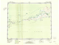 1952 Atka1952 Print · USGSThe Aleutian wilderness around Atka is captured in the early fifties, documenting a landscape of volcanic peaks and isolated maritime outposts. Researchers can trace the layout of the Atka settlement and nearby transportation hubs like the Commercial Airport and Seaplane Anchorage.
 - 1959 Map of Atka, 1971 Print
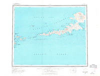 1959 Atka1971 Print · USGSThe Andreanof Islands are charted here during the mid-twentieth century, centered on the settlement of Atka. Researchers can trace the volcanic landscape near Korovin Volcano or locate remote maritime markers like Atka NE Base and Salt Island.2 unique versions available
 - 2021 Map of Atka C-1 NE, 2021 Print
 2021 Atka C-1 NE2021 Print · USGSThe Aleutian coast meets the sea at the start of the 2020s, showing a landscape defined by its indigenous geography and maritime hazards. Researchers can trace traditional Unangan place names like Aaguliigagix and Yaxagim Angaa alongside landmarks like Cape Kudugnak.
 - 2021 Map of Atka C-1 NW, 2021 Print
 2021 Atka C-1 NW2021 Print · USGSThe settlement of Atka and its surrounding coastal islands are shown in this recent survey. Researchers can trace local infrastructure and landmarks like Atka Airport, Korovin Bay Road, and Bolshoi Island.
 - 2021 Map of Atka D-1 SW, 2021 Print
 2021 Atka D-1 SW2021 Print · USGSAtka Island is depicted in the early 2020s, showing a volcanic landscape where the Pacific meets the Bering Sea. Geologists and local historians can trace indigenous landmarks and maritime features including Conical Volcano, Korovin Bay, and Tagalam Angtaa.
End of results
Showing maps 1-5 of 5
Frequently asked questions
- What are the different types of historical maps available for Atka?
- What is the oldest map of Atka?
- Where can I purchase historical maps of Atka for my home or office?
- Where can I download high-res historical maps of Atka?
- Are there historical topographic maps available for Atka?
- Is there historical aerial imagery available for Atka?
- Where are historical maps of Atka sourced from?