1900s (20th Century) Maps of Atka, Alaska
Explore 2 historic maps of Atka from the 1900s (20th Century). These maps offer a rare glimpse into what life looked like during the 1900s — showing old roads, neighborhoods, homes, and landmarks that have changed or disappeared over time.
Whether you're researching your family's past, planning a metal detecting trip, or studying how Atka's landscape evolved across the 1900s, these high-resolution maps are a powerful tool for exploring the history of this region.
- Focus on a specific era: All maps on this page are from the 1900s, giving you a focused view of this time period.
- See what’s changed: Compare century-old streets, trails, and buildings to today's modern landscape using overlays and satellite layers.
- Research with precision: Use these maps for genealogy, historical research, land use analysis, or educational projects.
- View, download, or print: Maps are fully viewable online in high resolution, and can be downloaded or printed for your own records.
Start exploring Atka's history through authentic maps from the 1900s. This is your window into the past.
Atka, AK maps
(2)- 1952 Map of Atka
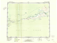 1952 Atka1952 Print · USGSThe Aleutian wilderness around Atka is captured in the early fifties, documenting a landscape of volcanic peaks and isolated maritime outposts. Researchers can trace the layout of the Atka settlement and nearby transportation hubs like the Commercial Airport and Seaplane Anchorage.
 - 1959 Map of Atka, 1971 Print
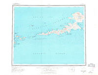 1959 Atka1971 Print · USGSThe Andreanof Islands are charted here during the mid-twentieth century, centered on the settlement of Atka. Researchers can trace the volcanic landscape near Korovin Volcano or locate remote maritime markers like Atka NE Base and Salt Island.2 unique versions available
End of results
Showing maps 1-2 of 2
Frequently asked questions
- What are the different types of historical maps available for Atka?
- What is the oldest map of Atka?
- Where can I purchase historical maps of Atka for my home or office?
- Where can I download high-res historical maps of Atka?
- Are there historical topographic maps available for Atka?
- Is there historical aerial imagery available for Atka?
- Where are historical maps of Atka sourced from?