Old Maps of Atka, Alaska for Academic Research
Study the evolution of Atka with 5 high-resolution historic maps. Whether you're teaching, researching, or modeling changes in land use, these maps provide essential visual documentation of urban, environmental, and geographic change.
- Analyze long-term change: Track patterns in development, transportation, and natural features.
- Ideal for environmental or urban studies: Support academic projects with primary historical map data.
- Use in the classroom or lab: Educators and researchers rely on these maps to bring historical context to life.
These maps are a powerful tool for teaching, research, and visualizing how Atka has changed over the decades.
Atka, AK maps
(5)- 1952 Map of Atka
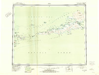 1952 Atka1952 Print · USGSThe Aleutian wilderness around Atka is captured in the early fifties, documenting a landscape of volcanic peaks and isolated maritime outposts. Researchers can trace the layout of the Atka settlement and nearby transportation hubs like the Commercial Airport and Seaplane Anchorage.
 - 1959 Map of Atka, 1971 Print
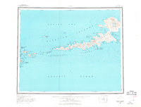 1959 Atka1971 Print · USGSThe Andreanof Islands are charted here during the mid-twentieth century, centered on the settlement of Atka. Researchers can trace the volcanic landscape near Korovin Volcano or locate remote maritime markers like Atka NE Base and Salt Island.2 unique versions available
 - 2021 Map of Atka C-1 NE, 2021 Print
 2021 Atka C-1 NE2021 Print · USGSThe Aleutian coast meets the sea at the start of the 2020s, showing a landscape defined by its indigenous geography and maritime hazards. Researchers can trace traditional Unangan place names like Aaguliigagix and Yaxagim Angaa alongside landmarks like Cape Kudugnak.
 - 2021 Map of Atka C-1 NW, 2021 Print
 2021 Atka C-1 NW2021 Print · USGSThe settlement of Atka and its surrounding coastal islands are shown in this recent survey. Researchers can trace local infrastructure and landmarks like Atka Airport, Korovin Bay Road, and Bolshoi Island.
 - 2021 Map of Atka D-1 SW, 2021 Print
 2021 Atka D-1 SW2021 Print · USGSAtka Island is depicted in the early 2020s, showing a volcanic landscape where the Pacific meets the Bering Sea. Geologists and local historians can trace indigenous landmarks and maritime features including Conical Volcano, Korovin Bay, and Tagalam Angtaa.
End of results
Showing maps 1-5 of 5
Frequently asked questions
- What are the different types of historical maps available for Atka?
- What is the oldest map of Atka?
- Where can I purchase historical maps of Atka for my home or office?
- Where can I download high-res historical maps of Atka?
- Are there historical topographic maps available for Atka?
- Is there historical aerial imagery available for Atka?
- Where are historical maps of Atka sourced from?