Old Maps of Manley Hot Springs, Alaska for Academic Research
Study the evolution of Manley Hot Springs with 6 high-resolution historic maps. Whether you're teaching, researching, or modeling changes in land use, these maps provide essential visual documentation of urban, environmental, and geographic change.
- Analyze long-term change: Track patterns in development, transportation, and natural features.
- Ideal for environmental or urban studies: Support academic projects with primary historical map data.
- Use in the classroom or lab: Educators and researchers rely on these maps to bring historical context to life.
These maps are a powerful tool for teaching, research, and visualizing how Manley Hot Springs has changed over the decades.
Manley Hot Springs, AK maps
(6)- 1951 Map of Tanana, 1952 Print
 1951 Tanana1952 Print · USGSThe confluence of the Yukon and Tanana rivers serves as the hub for this early 1950s interior Alaska record. Genealogists and historians can trace riverside settlements like Tanana and Rampart, as well as mining outposts at Tofty and Eureka.3 unique versions available
 - 1952 Map of Tanana A-2, 1956 Print
 1952 Tanana A-21956 Print · USGSThe Alaskan interior during the early fifties reveals a rugged frontier of gold mining and remote outposts. Researchers can trace the hydraulic mining Ditch lines and transport routes like the Sled Road connecting Manley Hot Springs to remote mountain Cabins.
 - 1953 Map of Tanana A-2, 1965 Print
 1953 Tanana A-21965 Print · USGSThe interior Alaska wilderness near the Tanana River was a landscape of remote outposts and mining activity in the early fifties. Researchers can locate specific sites like the Cem at Tofty, the Manley Hot Springs settlement, and several Landing Strips.3 unique versions available
 - 1956 Map of Tanana, 1962 Print
 1956 Tanana1962 Print · USGSInterior Alaska in the mid-fifties centers on the vital junction of the Yukon River and Tanana River. Researchers can trace the layout of Tanana and Rampart, locate the Placer Mine near Eureka, and follow the remote Winter Trail.4 unique versions available
 - 1960 Map of Tanana, 1978 Print
 1960 Tanana1978 Print · USGSThe Yukon and Tanana river systems converge in the mid-twentieth century, revealing a landscape of remote settlements and rugged mining districts. Researchers can trace the Tanana Allakaket Winter Trail and locate family sites at Manley Hot Springs or the Native Cem.4 unique versions available
 - 2017 Map of Tanana A-2 SE, 2017 Print
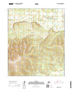 2017 Tanana A-2 SE2017 Print · USGSThe interior of Alaska near the Tanana River shows a landscape of thermal activity and early transit routes during the early twenty-first century. Researchers can trace the path of the Tofty Road and locate sites like Manley Hot Springs and McCloud Ranch Cr.
End of results
Showing maps 1-6 of 6
Frequently asked questions
- What are the different types of historical maps available for Manley Hot Springs?
- What is the oldest map of Manley Hot Springs?
- Where can I purchase historical maps of Manley Hot Springs for my home or office?
- Where can I download high-res historical maps of Manley Hot Springs?
- Are there historical topographic maps available for Manley Hot Springs?
- Is there historical aerial imagery available for Manley Hot Springs?
- Where are historical maps of Manley Hot Springs sourced from?