1940s Maps of Manokotak, Alaska
Explore 4 historic maps of Manokotak from the 1940s. These maps offer a rare glimpse into what life looked like during the 1940s — showing old roads, neighborhoods, homes, and landmarks that have changed or disappeared over time.
Whether you're researching your family's past, planning a metal detecting trip, or studying how Manokotak's landscape evolved across the 1940s, these high-resolution maps are a powerful tool for exploring the history of this region.
- Focus on a specific era: All maps on this page are from the 1940s, giving you a focused view of this time period.
- See what’s changed: Compare century-old streets, trails, and buildings to today's modern landscape using overlays and satellite layers.
- Research with precision: Use these maps for genealogy, historical research, land use analysis, or educational projects.
- View, download, or print: Maps are fully viewable online in high resolution, and can be downloaded or printed for your own records.
Start exploring Manokotak's history through authentic maps from the 1940s. This is your window into the past.
Manokotak, AK maps
(4)- 1945 Map of Nushagak Bay, 1954 Print
 1945 Nushagak Bay1954 Print · USGSNushagak Bay and the sprawling Alaskan coastline are captured in the mid-1940s, highlighting a landscape defined by salmon fishing and tidal waters. Researchers can locate remote outposts like Old Saltery, the busy Nushagak Cannery, and the coastal settlement of Clarks Point.
 - 1948 Map of Nushagak Bay D-4, 1975 Print
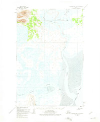
 1948 Nushagak Bay D-41975 Print · USGSThe Igushik River winds through the coastal wetlands of southwestern Alaska in the late 1940s. Researchers can trace the early layout of Manokotak, find the settlement of Tuklung, and locate the isolated Landing Strip used by bush pilots.
 - 1948 Map of Nushagak Bay D-3, 1975 Print
 1948 Nushagak Bay D-31975 Print · USGSCoastal Alaska in the late forties is defined here by the vast tidal reaches of Nushagak Bay and its winding river systems. Researchers can trace the shifting mudflats and survey markers like VABM 49 Snake near the mouth of the Snake River.2 unique versions available
 - 1949 Map of Nushagak Bay
 1949 Nushagak Bay1949 Print · USGSCoastal Alaska at the height of the mid-century salmon industry reveals a landscape of isolated canneries and subsistence camps. You can trace the shorelines to find sites like Nushagak Cannery, the Old Saltery, and the remote Igushik Cannery along the river.2 unique versions available
End of results
Showing maps 1-4 of 4
Frequently asked questions
- What are the different types of historical maps available for Manokotak?
- What is the oldest map of Manokotak?
- Where can I purchase historical maps of Manokotak for my home or office?
- Where can I download high-res historical maps of Manokotak?
- Are there historical topographic maps available for Manokotak?
- Is there historical aerial imagery available for Manokotak?
- Where are historical maps of Manokotak sourced from?