Old Maps of Ruby, Alaska for Academic Research
Study the evolution of Ruby with 9 high-resolution historic maps. Whether you're teaching, researching, or modeling changes in land use, these maps provide essential visual documentation of urban, environmental, and geographic change.
- Analyze long-term change: Track patterns in development, transportation, and natural features.
- Ideal for environmental or urban studies: Support academic projects with primary historical map data.
- Use in the classroom or lab: Educators and researchers rely on these maps to bring historical context to life.
These maps are a powerful tool for teaching, research, and visualizing how Ruby has changed over the decades.
Ruby, AK maps
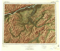
(9)- 1951 Map of Ruby
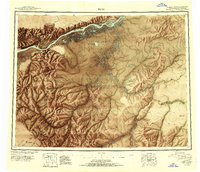 1951 Ruby1951 Print · USGSThe Yukon River interior comes to life in this mid-century study of the riverfront at Ruby and the surrounding gold-bearing creeks. Genealogists and historians can trace the seasonal routes of the Winter Trail, identify remote Placer Mines, and locate vanished sites like Placerville.2 unique versions available
 - 1952 Map of Ruby D-5, 1957 Print
 1952 Ruby D-51957 Print · USGSInterior Alaska's river systems are captured here in the early fifties, showing the remote confluence of the Yukon and Melozitna. Researchers can trace the path of the Abandoned Telegraph Line and locate several remote Cabin sites along Bootlegger Slough.3 unique versions available
 - 1952 Map of Ruby C-5, 1957 Print
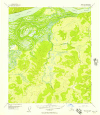
 1952 Ruby C-51957 Print · USGSThe riverfront settlement at Ruby and the winding Yukon River define this 1950s interior Alaska landscape. Trace the early aviation and communication sites at the Landing Area and Radio Towers, or locate the remote Cabins near Scow Mountain.4 unique versions available
 - 1952 Map of Ruby C-6, 1957 Print
 1952 Ruby C-61957 Print · USGSThe Yukon River interior comes alive in the mid-fifties, showing the rugged isolation of the Alaska territory before statehood. Researchers can locate remote dwellings and landmarks like The Hub Hill, the winding Ruby Slough, and Cabins along the river banks.2 unique versions available
 - 1952 Map of Ruby, 1958 Print
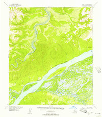
 1952 Ruby1958 Print · USGSThe Yukon River interior comes to life in the early fifties, showing the remote mining camps and river life of the region. Genealogists and researchers can trace the Telegraph Line and find historic sites like Poorman, Placerville, and Sulatna Crossing.8 unique versions available
 - 1964 Map of Ruby
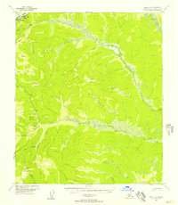
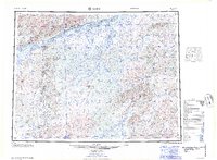 1964 Ruby1964 Print · USGSAlaska's interior river country and gold districts are shown here during the mid-1960s, centered on the Yukon River corridor. Researchers can trace historic mining activity and remote outposts like Poorman, Placerville, and the Kokrines Cem.
 - 2019 Map of Ruby D-5 SW, 2019 Print
 2019 Ruby D-5 SW2019 Print · USGSThe Yukon River corridor comes into sharp focus in this 2019 survey of the Alaska interior. Researchers and outdoorsmen can trace the braided channels around Straight Island and follow the winding path of the Melozitna River to Ninemile Point.
 - 2019 Map of Ruby C-6 NE, 2019 Print
 2019 Ruby C-6 NE2019 Print · USGSThe Yukon River interior comes to life in this contemporary survey of a historic riverside settlement. Researchers can trace the path of the Ruby / Poorman Road and explore the waterways of Ruby Slough and Little Bonanza Cr.
 - 2019 Map of Ruby C-5 NW, 2019 Print
 2019 Ruby C-5 NW2019 Print · USGSThe riverfront settlement of Ruby and its surrounding highlands are captured here in the late 2010s. Researchers can trace the path of the Ruby-Poorman Road and locate landmarks like Boston Dome and Ruby Airport.
End of results
Showing maps 1-9 of 9
Frequently asked questions
- What are the different types of historical maps available for Ruby?
- What is the oldest map of Ruby?
- Where can I purchase historical maps of Ruby for my home or office?
- Where can I download high-res historical maps of Ruby?
- Are there historical topographic maps available for Ruby?
- Is there historical aerial imagery available for Ruby?
- Where are historical maps of Ruby sourced from?