
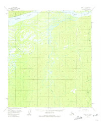
1952 Map of Ruby C-6
USGS Topo · Published 1957About this map
The Yukon River dominates the northern reaches of this mid-century Alaskan interior landscape, its massive channel wrapping around the expanse of Big Island. The complex hydrology of the river is marked by the branching paths of Ruby Slough and Big Ruby Slough, creating a low-lying riparian environment that contrasts with the rising elevations to the south. Further inland, the terrain is defined by a dense network of tributaries including Boston Creek and Main Creek which drain the surrounding highlands. Evidence of human presence is sparse and functional, indicated by isolated Cabins and a lone Cabin located near the southeastern corner. The name The Hub Hill stands out as a significant local landmark, likely serving as a navigational reference point for those traversing the wilderness between the river and the interior creeks like Little Bonanza Creek.
Find a feature on this map
12 named features on this map. Tap any name to fly to it.
Don’t see what you’re looking for? This feature index may not catch every label — zoom into the map to look around manually.
Map Details
Editions of this 1952 Ruby C-6 Map
2 editions found
Other maps of this area

1945 · Nulato
USGS Topo · 1:250,000

1951 · Nulato
USGS Topo · 1:250,000

1951 · Ruby
USGS Topo · 1:250,000

1952 · Nulato C-1
USGS Topo · 1:63,360

1952 · Nulato D-1
USGS Topo · 1:63,360

1952 · Ruby D-6
USGS Topo · 1:63,360

1952 · Nulato B-1
USGS Topo · 1:63,360

1952 · Ruby D-5
USGS Topo · 1:63,360

1952 · Ruby B-6
USGS Topo · 1:63,360

1952 · Ruby C-5
USGS Topo · 1:63,360