
1952 Map of Nulato C-1
USGS Topo · Published 1957About this map
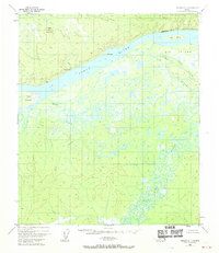
Mueller Mountain and Sandstone Bluff dominate the northern landscape of this interior Alaska region, overlooking the expansive Yukon River. The topography revealed by this mid-century aerial survey shows a complex network of waterways, including the winding Yuki River and its confluence near Yuki Island. An Abandoned Telegraph Line cuts across the northern bluffs, tracing a former communication corridor through the wilderness. South of the main river channel, the terrain is defined by a labyrinth of wetlands and secondary channels like Ruby Slough, which separates Big Island from the mainland. While mostly uninhabited, the presence of a lone Cabin and the naming of drainage systems like Gohn Creek and Whiskey Creek suggest the seasonal patterns of trapping, fishing, or prospecting that characterized this part of the Fourth Judicial Division.
Find a feature on this map
13 named features on this map. Tap any name to fly to it.
Don’t see what you’re looking for? This feature index may not catch every label — zoom into the map to look around manually.
Map Details
Editions of this 1952 Nulato C-1 Map
2 editions found
Other maps of this area

1945 · Nulato
USGS Topo · 1:250,000

1951 · Nulato
USGS Topo · 1:250,000

1951 · Ruby
USGS Topo · 1:250,000

1952 · Nulato D-1
USGS Topo · 1:63,360

1952 · Nulato B-2
USGS Topo · 1:63,360

1952 · Ruby D-6
USGS Topo · 1:63,360

1952 · Nulato B-1
USGS Topo · 1:63,360

1952 · Nulato C-2
USGS Topo · 1:63,360

1952 · Ruby B-6
USGS Topo · 1:63,360

1952 · Nulato D-2
USGS Topo · 1:63,360