
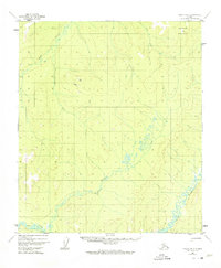
1952 Map of Nulato B-2
USGS Topo · Published 1957About this map
Ketlkede Mountain stands as a prominent topographical anchor in this interior Alaskan landscape, which was documented by the U.S. Geological Survey using aerial photography in the early 1950s. The region is defined by the winding course of the Yuki River, which meanders through the southern portion of the quadrangle. This era of mapping was characterized by the use of multiplex methods to translate aerial surveys into contour maps, capturing the intricate drainage patterns of the Kala Creek and Ketlkede Creek systems. The lack of roads or established trails at this time reflects the high degree of isolation in the Alaska-Fourth Judicial Division, where the natural terrain dictates the only routes of travel. Geologists and surveyors of the period relied on these specific watercourses as primary landmarks for navigation and territorial division.
Find a feature on this map
4 named features on this map. Tap any name to fly to it.
Don’t see what you’re looking for? This feature index may not catch every label — zoom into the map to look around manually.
Map Details
Editions of this 1952 Nulato B-2 Map
2 editions found
Other maps of this area

1945 · Nulato
USGS Topo · 1:250,000

1951 · Nulato
USGS Topo · 1:250,000

1952 · Nulato C-1
USGS Topo · 1:63,360

1952 · Nulato B-1
USGS Topo · 1:63,360

1952 · Nulato C-3
USGS Topo · 1:63,360

1952 · Nulato C-2
USGS Topo · 1:63,360

1952 · Nulato A-2
USGS Topo · 1:63,360

1952 · Nulato B-3
USGS Topo · 1:63,360

1952 · Nulato A-3
USGS Topo · 1:63,360
1952 · Nulato A-1
USGS Topo · 1:63,360