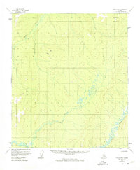
1952 Map of Nulato B-2
USGS Topo · Published 1974About this map
Yuki River meanders through the southern reaches of this interior landscape, defining a complex network of wetlands and seasonal drainages. During this mid-century period, small-scale aviation and communications infrastructure served the remote territory, evidenced by the Landing Strip and an adjacent Radio Tower situated north of the river. The terrain is characterized by significant elevations such as Ketlkede Mountain in the northeast, which overlooks the headwaters of numerous waterways.
Find a feature on this map
8 named features on this map. Tap any name to fly to it.
Don’t see what you’re looking for? This feature index may not catch every label — zoom into the map to look around manually.
Map Details
Editions of this 1952 Nulato B-2 Map
2 editions found
Other maps of this area

1945 · Nulato
USGS Topo · 1:250,000

1951 · Nulato
USGS Topo · 1:250,000

1952 · Nulato C-1
USGS Topo · 1:63,360

1952 · Nulato B-2
USGS Topo · 1:63,360

1952 · Nulato B-1
USGS Topo · 1:63,360

1952 · Nulato C-3
USGS Topo · 1:63,360

1952 · Nulato C-2
USGS Topo · 1:63,360

1952 · Nulato A-2
USGS Topo · 1:63,360

1952 · Nulato B-3
USGS Topo · 1:63,360

1952 · Nulato A-3
USGS Topo · 1:63,360