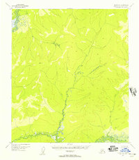
1952 Map of Nulato A-1
USGS Topo · Published 1957About this map
The North Fork and East Fork rivers dominate this 1952 topographic study of the Alaska interior, captured through aerial photography before the region saw significant development. The landscape is characterized by a dense network of drainages and unnamed ridges, with Camp Creek threading through the central terrain. A solitary survey marker, Vabm 1472, sits near a prominent Rock formation, providing a rare fixed point of reference in an area otherwise defined by its hydrological patterns. This map preserves the wilderness state of the Fourth Judicial Division as it appeared in the early 1950s, showing a total absence of roads or established settlements during this period of USGS mapping.
Find a feature on this map
6 named features on this map. Tap any name to fly to it.
Don’t see what you’re looking for? This feature index may not catch every label — zoom into the map to look around manually.
Map Details
Editions of this 1952 Nulato A-1 Map
This is the sole edition of this map. No revisions or reprints were ever made.
Other maps of this area

1945 · Nulato
USGS Topo · 1:250,000

1950 · Medfra
USGS Topo · 1:250,000

1951 · Ophir
USGS Topo · 1:250,000

1951 · Nulato
USGS Topo · 1:250,000

1951 · Ruby
USGS Topo · 1:250,000

1952 · Nulato B-2
USGS Topo · 1:63,360

1952 · Nulato B-1
USGS Topo · 1:63,360

1952 · Ruby B-6
USGS Topo · 1:63,360

1952 · Nulato A-2
USGS Topo · 1:63,360

1952 · Ruby A-6
USGS Topo · 1:63,360