
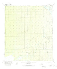
1952 Map of Ruby A-6
USGS Topo · Published 1957About this map
Poorman and the surrounding wilderness of the Yukon-Koyukuk region are captured here during a mid-century period of shifting interior Alaskan industry. The map illustrates a landscape defined by gold mining history, evidenced by the presence of a Strip Mine along Bonanza Creek and the notable settlement of Placerville, which is marked as abandoned by the time of this survey. A significant Winter Trail cuts north-south through the terrain, tracing a path between Timber Creek and Cache Creek, serving as a vital link in a region where seasonal travel was essential. The drainage systems of the Sulatna River and numerous gold-bearing tributaries like Gold Run and Poorman Creek dominate the topography. Local aviation infrastructure is visible through the Air Strip near Poorman and another Airstrip further south, highlighting the transition from ground-based trail transport to air travel in the Alaskan bush.
Find a feature on this map
34 named features on this map. Tap any name to fly to it.
Don’t see what you’re looking for? This feature index may not catch every label — zoom into the map to look around manually.
Map Details
Editions of this 1952 Ruby A-6 Map
2 editions found
Other maps of this area

1945 · Nulato
USGS Topo · 1:250,000

1950 · Medfra
USGS Topo · 1:250,000

1951 · Ophir
USGS Topo · 1:250,000

1951 · Nulato
USGS Topo · 1:250,000

1951 · Ruby
USGS Topo · 1:250,000

1952 · Nulato B-1
USGS Topo · 1:63,360

1952 · Ruby B-6
USGS Topo · 1:63,360

1952 · Ruby B-5
USGS Topo · 1:63,360

1952 · Ruby A-5
USGS Topo · 1:63,360
1952 · Nulato A-1
USGS Topo · 1:63,360