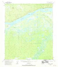
1952 Map of Nulato C-1
USGS Topo · Published 1970About this map
Mueller Mountain and Sandstone Bluff overlook a complex interior Alaska landscape where the mighty Yukon River meets a vast network of secondary waterways. In the early 1950s, this area remained largely wilderness, characterized by the shifting channels of Gohn Creek and the meandering Yuki River. Evidence of former communication infrastructure is preserved here in the form of an Abandoned Telegraph Line that cuts across the northern terrain. Large river features like Big Island and the narrow Ruby Slough define the river's path, while a solitary Cabin near the confluence of the Yukon and Whiskey Creek provides a rare marker of human habitation in this remote river corridor.
Find a feature on this map
15 named features on this map. Tap any name to fly to it.
Don’t see what you’re looking for? This feature index may not catch every label — zoom into the map to look around manually.
Map Details
Editions of this 1952 Nulato C-1 Map
2 editions found
Other maps of this area

1945 · Nulato
USGS Topo · 1:250,000

1951 · Nulato
USGS Topo · 1:250,000

1951 · Ruby
USGS Topo · 1:250,000

1952 · Nulato C-1
USGS Topo · 1:63,360

1952 · Nulato D-1
USGS Topo · 1:63,360

1952 · Nulato B-2
USGS Topo · 1:63,360

1952 · Ruby D-6
USGS Topo · 1:63,360

1952 · Nulato B-1
USGS Topo · 1:63,360

1952 · Nulato C-2
USGS Topo · 1:63,360

1952 · Ruby B-6
USGS Topo · 1:63,360