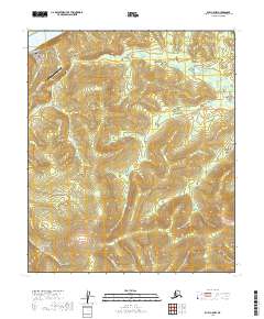
2019 Map of Ruby C-5 NW
USGS Topo · Published 2019About this map
The settlement of Ruby sits along the southern bank of the Yukon River, serving as a critical transport hub in this interior Alaskan landscape. This 2019 survey captures the modern infrastructure of the village, including Ruby Airport and a network of local thoroughfares such as Old Ruby Airport Road and River Road. The surrounding terrain is defined by the significant rise of Boston Dome to the south, which overlooks a complex drainage system fed by Boston Creek and Glacier Creek.
Find a feature on this map
26 named features on this map. Tap any name to fly to it.
Don’t see what you’re looking for? This feature index may not catch every label — zoom into the map to look around manually.
Map Details
Editions of this 2019 Ruby C-5 NW Map
This is the sole edition of this map. No revisions or reprints were ever made.
Other maps of this area

1951 · Ruby
USGS Topo · 1:250,000

1952 · Ruby D-6
USGS Topo · 1:63,360

1952 · Ruby D-5
USGS Topo · 1:63,360

1952 · Ruby C-5
USGS Topo · 1:63,360

1952 · Ruby C-6
USGS Topo · 1:63,360

1952 · Ruby
USGS Topo · 1:250,000

1964 · Ruby
USGS Topo · 1:250,000
2019 · Ruby D-6 SE
USGS Topo · 1:25,000
2019 · Ruby C-5 SE
USGS Topo · 1:25,000
2019 · Ruby C-5 SW
USGS Topo · 1:25,000