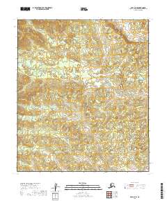
2019 Map of Ruby C-5 SE
USGS Topo · Published 2019About this map
Beaver Cr meanders across this interior Alaskan landscape, defining the hydrology of the Yukon-Koyukuk region. In this section of the Ruby quadrangle, the water drainage is further shaped by the presence of Hunter Cr and Big Cr, which carve through the subarctic terrain. The survey highlights the Public Land Survey System grid, demarcating townships such as t10s r18e and t11s r19e. This 2019 data reflects a sparsely settled wilderness where natural watercourses remain the primary geographic landmarks. The contour lines reveal a complex network of small hills and basins, illustrating the typical drainage patterns of the Alaskan interior before these waters eventually join larger river systems.
Find a feature on this map
7 named features on this map. Tap any name to fly to it.
Don’t see what you’re looking for? This feature index may not catch every label — zoom into the map to look around manually.
Map Details
Editions of this 2019 Ruby C-5 SE Map
This is the sole edition of this map. No revisions or reprints were ever made.
Other maps of this area

1951 · Ruby
USGS Topo · 1:250,000

1952 · Ruby B-4
USGS Topo · 1:63,360

1952 · Ruby C-5
USGS Topo · 1:63,360

1952 · Ruby B-5
USGS Topo · 1:63,360

1952 · Ruby C-4
USGS Topo · 1:63,360

1952 · Ruby
USGS Topo · 1:250,000

1964 · Ruby
USGS Topo · 1:250,000
2019 · Ruby C-4 NW
USGS Topo · 1:25,000
2019 · Ruby B-5 NE
USGS Topo · 1:25,000
2019 · Ruby B-4 NW
USGS Topo · 1:25,000