
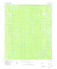
1952 Map of Ruby C-4
USGS Topo · Published 1957About this map
The Nowitna River meanders across this interior Alaskan landscape, characterized by complex oxbows and a dense network of marshes and small ponds. Based on 1952 aerial photography, this survey documents the intricate hydrologic patterns of the river corridor before modern human intervention or significant development. To the west, Beaver Creek carves a path through the wilderness, while Smiths Slough sits near the northern boundary. The terrain is remarkably void of roads or permanent settlements at this time, offering a clear record of the undisturbed natural drainage systems and topographic elevations within the Ruby (C-4) quadrangle. The map is a primary resource for understanding the pristine state of the Yukon-Koyukuk region during the mid-20th century.
Find a feature on this map
3 named features on this map. Tap any name to fly to it.
Don’t see what you’re looking for? This feature index may not catch every label — zoom into the map to look around manually.
Map Details
Editions of this 1952 Ruby C-4 Map
2 editions found
Other maps of this area

1951 · Ruby
USGS Topo · 1:250,000

1952 · Ruby D-4
USGS Topo · 1:63,360

1952 · Ruby D-5
USGS Topo · 1:63,360

1952 · Ruby C-3
USGS Topo · 1:63,360

1952 · Ruby B-4
USGS Topo · 1:63,360

1952 · Ruby C-5
USGS Topo · 1:63,360

1952 · Ruby B-3
USGS Topo · 1:63,360

1952 · Ruby B-5
USGS Topo · 1:63,360

1952 · Ruby D-3
USGS Topo · 1:63,360

1952 · Ruby
USGS Topo · 1:250,000