
1952 Map of Ruby C-3
USGS Topo · Published 1957About this map
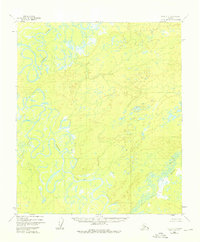
The Nowitna River meanders in tight, complex oxbows through this portion of the Alaska interior, dominating the western half of the landscape. This 1952 survey, compiled from aerial photography, captures a territory largely defined by its intricate water systems rather than human infrastructure. The presence of a solitary Cabin near the southern bend of the Sulatna River serves as a rare marker of habitation in this wilderness. To the southeast, the Little Mud River winds through the lowlands, illustrating the extensive drainage patterns that characterize the Yukon-Koyukuk region. The absence of roads or established trails on this sheet highlights the reliance on river corridors for navigation and survival in the mid-20th century.
Find a feature on this map
4 named features on this map. Tap any name to fly to it.
Don’t see what you’re looking for? This feature index may not catch every label — zoom into the map to look around manually.
Map Details
Editions of this 1952 Ruby C-3 Map
4 editions found

Other maps of this area

1951 · Ruby
USGS Topo · 1:250,000

1952 · Ruby B-2
USGS Topo · 1:63,360

1952 · Ruby D-4
USGS Topo · 1:63,360

1952 · Ruby B-4
USGS Topo · 1:63,360

1952 · Ruby C-2
USGS Topo · 1:63,360

1952 · Ruby B-3
USGS Topo · 1:63,360

1952 · Ruby D-3
USGS Topo · 1:63,360

1952 · Ruby D-2
USGS Topo · 1:63,360

1952 · Ruby C-4
USGS Topo · 1:63,360

1952 · Ruby
USGS Topo · 1:250,000