
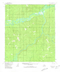
1952 Map of Ruby B-2
USGS Topo · Published 1957About this map
The Nowitna River meanders sharply through the heart of the Alaska interior in this mid-century survey, defining a landscape of complex waterways and dense marshland. Along its course, a solitary Cabin stands as the only named structure, reflecting the sparse human presence in this region during the early 1950s. The river is joined by the Titna River and Big Mud River, forming an intricate drainage system that dominates the topography. High points such as VABM 2160 Nowitna and VABM 2048 Mastodon provide the primary survey control for the surrounding highlands. These peaks overlook Mastodon Creek, where the terrain transitions from steep ridges to broad, waterlogged flats. The lack of roads or established trails highlights the river-dependent nature of travel and subsistence in this part of the Yukon-Koyukuk region.
Find a feature on this map
7 named features on this map. Tap any name to fly to it.
Don’t see what you’re looking for? This feature index may not catch every label — zoom into the map to look around manually.
Map Details
Editions of this 1952 Ruby B-2 Map
2 editions found
Other maps of this area

1951 · Ruby
USGS Topo · 1:250,000

1952 · Ruby A-2
USGS Topo · 1:63,360

1952 · Ruby B-1
USGS Topo · 1:63,360

1952 · Ruby A-3
USGS Topo · 1:63,360

1952 · Ruby A-1
USGS Topo · 1:63,360

1952 · Ruby C-3
USGS Topo · 1:63,360

1952 · Ruby C-1
USGS Topo · 1:63,360

1952 · Ruby C-2
USGS Topo · 1:63,360

1952 · Ruby B-3
USGS Topo · 1:63,360

1952 · Ruby
USGS Topo · 1:250,000