
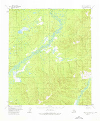
1952 Map of Ruby C-2
USGS Topo · Published 1957About this map
The Little Mud River winds through the heart of this mid-century survey, cutting a distinctive path through the Alaskan interior within the Fourth Judicial Division. This map, derived from 1952 aerial photography, documents a wilderness landscape devoid of any formal roads or established trails at the time of mapping. The terrain is defined by a dense network of high ridges and deep drainages, with numerous unnamed summits reaching over 1,000 feet in elevation. The concentration of muskeg and braided water channels surrounding the Little Mud River illustrates the complex hydrologic patterns of the subarctic environment before significant modern human intervention.
Find a feature on this map
1 named feature on this map. Tap any name to fly to it.
Don’t see what you’re looking for? This feature index may not catch every label — zoom into the map to look around manually.
Map Details
Editions of this 1952 Ruby C-2 Map
2 editions found
Other maps of this area

1951 · Ruby
USGS Topo · 1:250,000

1952 · Ruby B-1
USGS Topo · 1:63,360

1952 · Ruby B-2
USGS Topo · 1:63,360

1952 · Ruby C-3
USGS Topo · 1:63,360

1952 · Ruby C-1
USGS Topo · 1:63,360

1952 · Ruby D-1
USGS Topo · 1:63,360

1952 · Ruby B-3
USGS Topo · 1:63,360

1952 · Ruby D-3
USGS Topo · 1:63,360

1952 · Ruby D-2
USGS Topo · 1:63,360

1952 · Ruby
USGS Topo · 1:250,000