
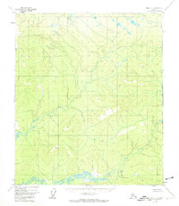
1952 Map of Ruby C-1
USGS Topo · Published 1957About this map
The Big Mud River snakes across the southern reaches of this interior Alaskan wilderness, as documented by the Geological Survey during the early 1950s. The landscape is defined by its drainage systems and high points, where surveying parties established vertical angle bench marks (VABMs) to master the geography. Notable peaks include VABM 2045 Two and VABM 1923 Seven, serving as critical triangulation points for mapping the remote terrain.
Find a feature on this map
6 named features on this map. Tap any name to fly to it.
Don’t see what you’re looking for? This feature index may not catch every label — zoom into the map to look around manually.
Map Details
Editions of this 1952 Ruby C-1 Map
2 editions found
Other maps of this area

1948 · Kantishna River
USGS Topo · 1:250,000

1951 · Kantishna River
USGS Topo · 1:250,000

1951 · Ruby
USGS Topo · 1:250,000

1952 · Ruby B-1
USGS Topo · 1:63,360

1952 · Ruby B-2
USGS Topo · 1:63,360

1952 · Kantishna River C-6
USGS Topo · 1:63,360

1952 · Ruby D-1
USGS Topo · 1:63,360

1952 · Ruby C-2
USGS Topo · 1:63,360

1952 · Kantishna River
USGS Topo · 1:250,000

1952 · Kantishna River B-6
USGS Topo · 1:63,360