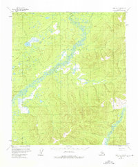
1952 Map of Ruby C-2
USGS Topo · Published 1976About this map
The Little River winds through this interior Alaskan landscape, defining a complex network of wetlands and drainage patterns as captured in 1952. Photogrammetric methods from aerial surveys reveal an intricate topography where the river meanders across a broad valley, flanked by numerous small lakes and swamps. These water features are essential markers for understanding the historical hydrology of the region before minor revisions were recorded in 1973. In the southeastern portion of the quadrangle, Grand Creek cuts through more pronounced elevation, offering a clear contrast between the low-lying river basin and the surrounding uplands. This survey serves as a vital record of a remote wilderness area, noting the absence of established roads or trails during the mid-twentieth century.
Find a feature on this map
2 named features on this map. Tap any name to fly to it.
Don’t see what you’re looking for? This feature index may not catch every label — zoom into the map to look around manually.
Map Details
Editions of this 1952 Ruby C-2 Map
2 editions found
Other maps of this area

1951 · Ruby
USGS Topo · 1:250,000

1952 · Ruby B-1
USGS Topo · 1:63,360

1952 · Ruby B-2
USGS Topo · 1:63,360

1952 · Ruby C-3
USGS Topo · 1:63,360

1952 · Ruby C-1
USGS Topo · 1:63,360

1952 · Ruby D-1
USGS Topo · 1:63,360

1952 · Ruby C-2
USGS Topo · 1:63,360

1952 · Ruby B-3
USGS Topo · 1:63,360

1952 · Ruby D-3
USGS Topo · 1:63,360

1952 · Ruby D-2
USGS Topo · 1:63,360