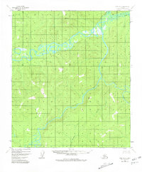
1952 Map of Ruby B-2
USGS Topo · Published 1981About this map
The Nowitna River meanders across this interior Alaskan landscape, creating a complex network of wetlands and oxbow lakes typical of the region's riverine geography in the early 1950s. A solitary Cabin situated near the confluence of the Titna River and the Nowitna represents the only named structural evidence of human habitation in this expansive wilderness. This indicates the area’s role as a site for seasonal subsistence or trapping rather than permanent settlement. The drainage patterns are defined by several notable tributaries, including Mastodon Creek and California Creek to the south, and the Big Mud River and Grand Creek in the northeast. The topography, mapped via photogrammetric methods from 1952 aerial photography, documents the natural state of these waterways before later twentieth-century environmental shifts.
Find a feature on this map
7 named features on this map. Tap any name to fly to it.
Don’t see what you’re looking for? This feature index may not catch every label — zoom into the map to look around manually.
Map Details
Editions of this 1952 Ruby B-2 Map
2 editions found
Other maps of this area

1951 · Ruby
USGS Topo · 1:250,000

1952 · Ruby A-2
USGS Topo · 1:63,360

1952 · Ruby B-1
USGS Topo · 1:63,360

1952 · Ruby B-2
USGS Topo · 1:63,360

1952 · Ruby A-3
USGS Topo · 1:63,360

1952 · Ruby A-1
USGS Topo · 1:63,360

1952 · Ruby C-3
USGS Topo · 1:63,360

1952 · Ruby C-1
USGS Topo · 1:63,360

1952 · Ruby C-2
USGS Topo · 1:63,360

1952 · Ruby B-3
USGS Topo · 1:63,360