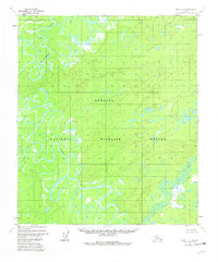
1952 Map of Ruby C-3
USGS Topo · Published 1981About this map
Nowitna National Wildlife Refuge dominates this interior landscape, defined by the complex, meandering path of the Nowitna River. Based on aerial photography from the early 1950s, the map reveals a wilderness of wetlands and oxbow lakes where the river turns back upon itself in intricate loops. Small tributaries like the Sulatna River and Little Mud River feed into this vast drainage system, highlighting the natural hydrological patterns before extensive modern land management. A single, isolated Cabin is marked along the riverbank, indicating the sparse human presence and the reliance on waterways for travel and seasonal habitation in this part of the Yukon-Koyukuk region.
Find a feature on this map
5 named features on this map. Tap any name to fly to it.
Don’t see what you’re looking for? This feature index may not catch every label — zoom into the map to look around manually.
Map Details
Editions of this 1952 Ruby C-3 Map
4 editions found

Other maps of this area

1951 · Ruby
USGS Topo · 1:250,000

1952 · Ruby B-2
USGS Topo · 1:63,360

1952 · Ruby D-4
USGS Topo · 1:63,360

1952 · Ruby C-3
USGS Topo · 1:63,360

1952 · Ruby B-4
USGS Topo · 1:63,360

1952 · Ruby C-2
USGS Topo · 1:63,360

1952 · Ruby B-3
USGS Topo · 1:63,360

1952 · Ruby D-3
USGS Topo · 1:63,360

1952 · Ruby D-2
USGS Topo · 1:63,360

1952 · Ruby C-4
USGS Topo · 1:63,360