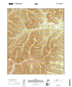
2019 Map of Ruby C-5 SW
USGS Topo · Published 2019About this map
Ruby-Poorman Road cuts a distinct path through this interior Alaska landscape, serving as the primary corridor through the high-elevation terrain of the Yukon-Koyukuk region. The area is defined by significant landmarks such as Scow Mtn and the prominent Devils Thumb, which watch over a dense network of drainages. The complex hydrography includes the meandering Beaver Cr and numerous smaller tributaries like Thirteenmile Cr, Big Joe Cr, and Little Joe Cr.
Find a feature on this map
18 named features on this map. Tap any name to fly to it.
Don’t see what you’re looking for? This feature index may not catch every label — zoom into the map to look around manually.
Map Details
Editions of this 2019 Ruby C-5 SW Map
This is the sole edition of this map. No revisions or reprints were ever made.
Other maps of this area

1951 · Ruby
USGS Topo · 1:250,000

1952 · Ruby B-6
USGS Topo · 1:63,360

1952 · Ruby C-5
USGS Topo · 1:63,360

1952 · Ruby B-5
USGS Topo · 1:63,360

1952 · Ruby C-6
USGS Topo · 1:63,360

1952 · Ruby
USGS Topo · 1:250,000

1964 · Ruby
USGS Topo · 1:250,000
2019 · Ruby B-5 NE
USGS Topo · 1:25,000
2019 · Ruby C-5 SE
USGS Topo · 1:25,000
2019 · Ruby B-6 NE
USGS Topo · 1:25,000