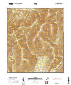
2019 Map of Ruby B-6 NE
USGS Topo · Published 2019About this map
The Ruby / Poorman Road serves as the primary north-south artery through this interior landscape, following the high ground between the various drainages of the Yukon-Koyukuk region. The map reveals a land defined by its mining-era topography, where named drainages like Last Chance Gulch and Bear Gulch indicate the historical prospecting activity that once drew people to these remote creek beds.
Find a feature on this map
18 named features on this map. Tap any name to fly to it.
Don’t see what you’re looking for? This feature index may not catch every label — zoom into the map to look around manually.
Map Details
Editions of this 2019 Ruby B-6 NE Map
This is the sole edition of this map. No revisions or reprints were ever made.
Other maps of this area

1951 · Ruby
USGS Topo · 1:250,000

1952 · Ruby B-6
USGS Topo · 1:63,360

1952 · Ruby C-5
USGS Topo · 1:63,360

1952 · Ruby B-5
USGS Topo · 1:63,360

1952 · Ruby C-6
USGS Topo · 1:63,360

1952 · Ruby
USGS Topo · 1:250,000

1964 · Ruby
USGS Topo · 1:250,000
2019 · Ruby C-5 SW
USGS Topo · 1:25,000
2019 · Ruby B-6 SE
USGS Topo · 1:25,000
2019 · Ruby B-6 SW
USGS Topo · 1:25,000