1900s (20th Century) Maps of Saint Paul, St. Paul
Explore 4 historic maps of Saint Paul from the 1900s (20th Century). These maps offer a rare glimpse into what life looked like during the 1900s — showing old roads, neighborhoods, homes, and landmarks that have changed or disappeared over time.
Whether you're researching your family's past, planning a metal detecting trip, or studying how Saint Paul's landscape evolved across the 1900s, these high-resolution maps are a powerful tool for exploring the history of this region.
- Focus on a specific era: All maps on this page are from the 1900s, giving you a focused view of this time period.
- See what’s changed: Compare century-old streets, trails, and buildings to today's modern landscape using overlays and satellite layers.
- Research with precision: Use these maps for genealogy, historical research, land use analysis, or educational projects.
- View, download, or print: Maps are fully viewable online in high resolution, and can be downloaded or printed for your own records.
Start exploring Saint Paul's history through authentic maps from the 1900s. This is your window into the past.
Saint Paul, St. Paul maps
(4)- 1948 Map of Pribilof Islands, 1955 Print
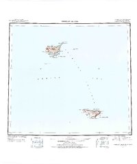 1948 Pribilof Islands1955 Print · USGSThe remote Pribilof Islands are documented here just after the war, showing the essential settlements and coastal geography of this Bering Sea archipelago. Researchers can trace the landing sites and terrain at St Paul, St. George, Village Cove, and Garden Cove.4 unique versions available
 - 1949 Map of Pribilof Islands
 1949 Pribilof Islands1949 Print · USGSThe Bering Sea islands of St. Paul and St. George are shown in the late 1940s during a pivotal era for Alaska’s maritime territory. Researchers can trace remote coastal points and settlements like St Paul and St. George, or locate landmarks such as Walrus Island and Village Cove.2 unique versions available
 - 1958 Map of Pribilof Islands
 1958 Pribilof Islands1958 Print · USGSThe isolated Pribilof archipelago appears here in the late fifties, detailing the rugged coasts of St. Paul Island and St. George Island. Researchers can locate the primary settlements of St Paul and St. George alongside remote landmarks like Rush Hill and Walrus Island.
 - 1969 Map of Pribilof Islands
 1969 Pribilof Islands1969 Print · USGSThe remote Pribilof archipelago appears during the late sixties, centered on the vital maritime outposts of St Paul and St. George. Researchers can trace the volcanic topography from Rush Hill to coastal features like Village Cove and English Bay.
End of results
Showing maps 1-4 of 4
Frequently asked questions
- What are the different types of historical maps available for Saint Paul?
- What is the oldest map of Saint Paul?
- Where can I purchase historical maps of Saint Paul for my home or office?
- Where can I download high-res historical maps of Saint Paul?
- Are there historical topographic maps available for Saint Paul?
- Is there historical aerial imagery available for Saint Paul?
- Where are historical maps of Saint Paul sourced from?