Old Maps of Saint Paul, St. Paul for Genealogy
Trace your family roots with 6 historic maps of Saint Paul. These high-res maps reveal old neighborhoods, homesites, landmarks, and streets — helping you uncover where your ancestors lived and how the area evolved over time.
- Explore historic neighborhoods: Identify where your relatives may have lived in the 1800s or 1900s.
- Compare maps over time: Trace the changes in streets, buildings, and landmarks for multi-generational research.
- Perfect for genealogy & ancestry research: Used by family historians and researchers to map out lineage and migration.
These maps are an incredible resource for exploring your personal connection to Saint Paul's past.
Saint Paul, St. Paul maps
(6)- 1948 Map of Pribilof Islands, 1955 Print
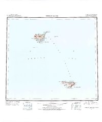 1948 Pribilof Islands1955 Print · USGSThe remote Pribilof Islands are documented here just after the war, showing the essential settlements and coastal geography of this Bering Sea archipelago. Researchers can trace the landing sites and terrain at St Paul, St. George, Village Cove, and Garden Cove.4 unique versions available
 - 1949 Map of Pribilof Islands
 1949 Pribilof Islands1949 Print · USGSThe Bering Sea islands of St. Paul and St. George are shown in the late 1940s during a pivotal era for Alaska’s maritime territory. Researchers can trace remote coastal points and settlements like St Paul and St. George, or locate landmarks such as Walrus Island and Village Cove.2 unique versions available
 - 1958 Map of Pribilof Islands
 1958 Pribilof Islands1958 Print · USGSThe isolated Pribilof archipelago appears here in the late fifties, detailing the rugged coasts of St. Paul Island and St. George Island. Researchers can locate the primary settlements of St Paul and St. George alongside remote landmarks like Rush Hill and Walrus Island.
 - 1969 Map of Pribilof Islands
 1969 Pribilof Islands1969 Print · USGSThe remote Pribilof archipelago appears during the late sixties, centered on the vital maritime outposts of St Paul and St. George. Researchers can trace the volcanic topography from Rush Hill to coastal features like Village Cove and English Bay.
 - 2001 Map of Saint Paul Island West, 2002 Print
 2001 Saint Paul Island West2002 Print · USGSSaint Paul Island in the Pribilof chain appears at the start of the millennium, documenting the remote Bering Sea settlement and its surrounding rookeries. Trace the local landscape from the village of St Paul to landmarks like Telegraph Hill and Antone Lake.
 - 2020 Map of Pribilof Islands C-4 NW, 2020 Print
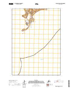 2020 Pribilof Islands C-4 NW2020 Print · USGSThe remote island community of St. Paul in the Bering Sea is documented here in the early twenty-first century. Researchers can trace the local road system and coastal features like Salt Lagoon, Black Bluffs, and the sands at Tolstoi Sands.
End of results
Showing maps 1-6 of 6
Frequently asked questions
- What are the different types of historical maps available for Saint Paul?
- What is the oldest map of Saint Paul?
- Where can I purchase historical maps of Saint Paul for my home or office?
- Where can I download high-res historical maps of Saint Paul?
- Are there historical topographic maps available for Saint Paul?
- Is there historical aerial imagery available for Saint Paul?
- Where are historical maps of Saint Paul sourced from?