1900s (20th Century) Maps of Cane, Arizona
Explore 9 historic maps of Cane from the 1900s (20th Century). These maps offer a rare glimpse into what life looked like during the 1900s — showing old roads, neighborhoods, homes, and landmarks that have changed or disappeared over time.
Whether you're researching your family's past, planning a metal detecting trip, or studying how Cane's landscape evolved across the 1900s, these high-resolution maps are a powerful tool for exploring the history of this region.
- Focus on a specific era: All maps on this page are from the 1900s, giving you a focused view of this time period.
- See what’s changed: Compare century-old streets, trails, and buildings to today's modern landscape using overlays and satellite layers.
- Research with precision: Use these maps for genealogy, historical research, land use analysis, or educational projects.
- View, download, or print: Maps are fully viewable online in high resolution, and can be downloaded or printed for your own records.
Start exploring Cane's history through authentic maps from the 1900s. This is your window into the past.
Cane, AZ maps
(9)- 1936 Map of Jacobs Lake
 1936 Jacobs Lake1936 Print · USGSThe Kaibab Plateau in the mid-1930s was a landscape of high-altitude forests and remote truck trails. Genealogists and researchers can trace the early road network of U S Highway No 89 and locate isolated outposts like the Jacobs Lake Ranger Station.
 - 1940 Map of Jacob Lake
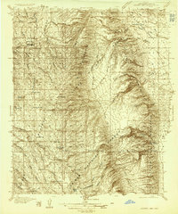
 1940 Jacob Lake1940 Print · USGSThe high plateau of the Arizona Strip is captured here in the mid-1930s, showing the early forest service and ranching footprint. You can trace the historic Kane Trail, locate the Jacob Lake Ranger Sta, and identify remote watering spots like Kane Springs.2 unique versions available
 - 1953 Map of Jacobs Lake, 1955 Print
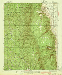
 1953 Jacobs Lake1955 Print · USGSThe Kaibab Plateau and the gateway to the North Rim appear here during a period of forest management and highway development in the mid-1950s. Researchers can trace historic routes like the Grand Canyon Highway and locate remote outposts like Jacob Lake Ranger Sta and Kane Corral.4 unique versions available
 - 1953 Map of Grand Canyon, 1967 Print
 1953 Grand Canyon1967 Print · USGSArizona's northern frontier is captured here in the mid-twentieth century, from the high plateaus to the desert basins. Trace early routes like Arizona 67, explore the isolated Moccasin settlement, or locate early landmarks such as Mount Trumbull.3 unique versions available
 - 1957 Map of Grand Canyon
 1957 Grand Canyon1957 Print · USGSNorthern Arizona in the mid-fifties presents a sparsely settled expanse of high plateaus and ranching outposts surrounding the great canyon. Genealogists and historians can trace family land at Diamond Butte Ranch, locate the Moccasin settlement, or study the magnesium works at Black Diamond Mine.
 - 1958 Map of Grand Canyon
 1958 Grand Canyon1958 Print · USGSNorthern Arizona in the late fifties was a landscape of remote cattle ranches and timber operations spanning from the Virgin Mountains to the Kaibab Forest. Researchers can locate family outposts like Bundy Ranch, trace the Temple Trail, or find the Parashant Lumber Mill.
 - 1960 Map of Grand Canyon
 1960 Grand Canyon1960 Print · USGSThe Arizona strip and the Colorado River corridor appear in the 1950s as a vast network of isolated plateaus and remote outposts. Researchers can trace historic ranching and tribal lands including Supai, the Kaibab Indian Reservation, and the Mt Trumbull Post Office.
 - 1984 Map of Fredonia
 1984 Fredonia1984 Print · USGSThe Arizona Strip in the mid-1980s reveals a sparse network of settlements and vast public lands. Genealogists and historians can trace the foundations of Fredonia and Colorado City or locate landmarks like Pipe Spring National Monument.2 unique versions available
 - 1988 Map of Cane
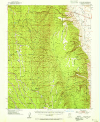
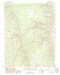 1988 Cane1988 Print · USGSCoconino County was characterized by vast protected wilderness and remote ranching outposts in the late 1980s. Historians and researchers can trace the management of water and livestock through features like Cane Springs, Cane Aqueduct, and the corral.2 unique versions available
End of results
Showing maps 1-9 of 9
Frequently asked questions
- What are the different types of historical maps available for Cane?
- What is the oldest map of Cane?
- Where can I purchase historical maps of Cane for my home or office?
- Where can I download high-res historical maps of Cane?
- Are there historical topographic maps available for Cane?
- Is there historical aerial imagery available for Cane?
- Where are historical maps of Cane sourced from?