1900s (20th Century) Maps of Tuba City, Arizona
Explore 8 historic maps of Tuba City from the 1900s (20th Century). These maps offer a rare glimpse into what life looked like during the 1900s — showing old roads, neighborhoods, homes, and landmarks that have changed or disappeared over time.
Whether you're researching your family's past, planning a metal detecting trip, or studying how Tuba City's landscape evolved across the 1900s, these high-resolution maps are a powerful tool for exploring the history of this region.
- Focus on a specific era: All maps on this page are from the 1900s, giving you a focused view of this time period.
- See what’s changed: Compare century-old streets, trails, and buildings to today's modern landscape using overlays and satellite layers.
- Research with precision: Use these maps for genealogy, historical research, land use analysis, or educational projects.
- View, download, or print: Maps are fully viewable online in high resolution, and can be downloaded or printed for your own records.
Start exploring Tuba City's history through authentic maps from the 1900s. This is your window into the past.
Tuba City, AZ maps
(8)- 1956 Map of Marble Canyon, 1964 Print
 1956 Marble Canyon1964 Print · USGSNorthern Arizona and the borderlands of Utah are mapped here in the mid-fifties, showing a landscape defined by traditional trading posts and early uranium mining. Trace old routes between Tuba City and Kayenta, and locate historic sites like Lees Ferry and Inscription House Trading Post.4 unique versions available
 - 1959 Map of Marble Canyon
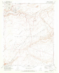
 1959 Marble Canyon1959 Print · USGSNorthern Arizona in the late fifties is a vast landscape of tribal lands and desert plateaus defined by the carving of the Colorado River. Trace family roots and regional history at Tuba City, the Chilchinbito Trading Post, or the ancient Inscription House Ruin.
 - 1961 Map of Marble Canyon
 1961 Marble Canyon1961 Print · USGSThe northern Arizona desert in the early sixties reveals a landscape of tribal lands and canyon crossings. Trace the old river life at Lees Ferry, find the Uranium mill at Tuba City, and locate the iconic Elephant Feet landmarks.
 - 1969 Map of Moenkopi, 1972 Print
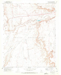
 1969 Moenkopi1972 Print · USGSThe Navajo Indian Reservation comes into focus during the late sixties, showcasing the high-desert landscapes of Coconino County. Genealogists and historians can trace local life through features like the Cem, the small settlement of Tahniti, and named natural landmarks such as Three Wise Men and Owls Cap.
 - 1969 Map of Tuba City, 1972 Print
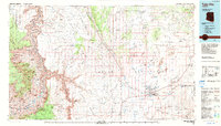
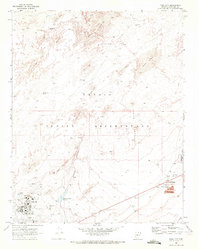 1969 Tuba City1972 Print · USGSIn the late sixties, Tuba City stood as a vital hub within the Navajo Indian Reservation, surrounded by an arid landscape of dunes and springs. Researchers can trace the mid-century community layout from the Hospital and schools to rural landmarks like Charley Day Well and the Rare Metals industrial site.
 - 1969 Map of Moenave, 1972 Print
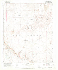 1969 Moenave1972 Print · USGSSettlement and survival in the high desert of the Navajo Indian Reservation are documented here in the late sixties. Researchers can locate remote family landmarks and water sources like the Charlie Secody Well, Natanabah Well, and Moenave.
 - 1969 Map of Moenave SE, 1972 Print
 1969 Moenave SE1972 Print · USGSThe high mesas of the Navajo Nation come into focus during the late sixties, showing a landscape defined by traditional movement and modern utility. Researchers can trace remote routes like the Jeep Trails connecting Billy Spring, Toh Nee Di Kishi, and the wide Kerley Valley.
 - 1983 Map of Tuba City
 1983 Tuba City1983 Print · USGSThe Navajo Nation and the eastern rim of the Grand Canyon meet in this early 1980s survey of Coconino County. Genealogists and researchers can locate remote outposts like The Gap and Moenave alongside traditional water sites such as Klage Toh and Mesa Spring.2 unique versions available
End of results
Showing maps 1-8 of 8
Top cities near Tuba City
- Tuba City historical maps
- Bodaway Gap historical maps
- Moenkopi historical maps
- Moenkopi historical maps
- Cameron historical maps
Top neighborhoods of Tuba City
Frequently asked questions
- What are the different types of historical maps available for Tuba City?
- What is the oldest map of Tuba City?
- Where can I purchase historical maps of Tuba City for my home or office?
- Where can I download high-res historical maps of Tuba City?
- Are there historical topographic maps available for Tuba City?
- Is there historical aerial imagery available for Tuba City?
- Where are historical maps of Tuba City sourced from?