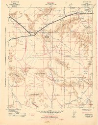
1940s Maps of Bouse, Arizona
Explore 3 historic maps of Bouse from the 1940s. These maps offer a rare glimpse into what life looked like during the 1940s — showing old roads, neighborhoods, homes, and landmarks that have changed or disappeared over time.
Whether you're researching your family's past, planning a metal detecting trip, or studying how Bouse's landscape evolved across the 1940s, these high-resolution maps are a powerful tool for exploring the history of this region.
- Focus on a specific era: All maps on this page are from the 1940s, giving you a focused view of this time period.
- See what’s changed: Compare century-old streets, trails, and buildings to today's modern landscape using overlays and satellite layers.
- Research with precision: Use these maps for genealogy, historical research, land use analysis, or educational projects.
- View, download, or print: Maps are fully viewable online in high resolution, and can be downloaded or printed for your own records.
Start exploring Bouse's history through authentic maps from the 1940s. This is your window into the past.
Bouse, AZ maps
(3)- 1942 Map of Signal
 1942 Signal1942 Print · USGSNorthwestern Arizona was a rugged network of mining camps and river crossings during the early years of the war. Researchers can trace the isolated roads connecting Signal, the mines at Bagdad, and the remote desert outposts of Swansea and Alamo.
 - 1942 Map of Blythe
 1942 Blythe1942 Print · USGSThe Lower Colorado River valley appears here in the early 1940s, showcasing the agricultural development of the Palo Verde Mesa alongside a booming mining industry. Researchers can locate remote desert outposts and extraction sites like Midland, the U S Gypsum Mine, and Nortons Landing.2 unique versions available
 - 1942 Map of Vicksburg
 1942 Vicksburg1942 Print · USGSWestern Arizona's desert landscape during the early war years is defined here by isolated rail stops and vital water points. Researchers can trace the Atchison Topeka and Santa Fe line through Salome and Vicksburg or locate remote sites like Reids Ranch and the Kofa Mine.
End of results
Showing maps 1-3 of 3
Top cities near Bouse
Frequently asked questions
- What are the different types of historical maps available for Bouse?
- What is the oldest map of Bouse?
- Where can I purchase historical maps of Bouse for my home or office?
- Where can I download high-res historical maps of Bouse?
- Are there historical topographic maps available for Bouse?
- Is there historical aerial imagery available for Bouse?
- Where are historical maps of Bouse sourced from?