1960s Maps of Bouse, Arizona
Explore 9 historic maps of Bouse from the 1960s. These maps offer a rare glimpse into what life looked like during the 1960s — showing old roads, neighborhoods, homes, and landmarks that have changed or disappeared over time.
Whether you're researching your family's past, planning a metal detecting trip, or studying how Bouse's landscape evolved across the 1960s, these high-resolution maps are a powerful tool for exploring the history of this region.
- Focus on a specific era: All maps on this page are from the 1960s, giving you a focused view of this time period.
- See what’s changed: Compare century-old streets, trails, and buildings to today's modern landscape using overlays and satellite layers.
- Research with precision: Use these maps for genealogy, historical research, land use analysis, or educational projects.
- View, download, or print: Maps are fully viewable online in high resolution, and can be downloaded or printed for your own records.
Start exploring Bouse's history through authentic maps from the 1960s. This is your window into the past.
Bouse, AZ maps
(9)- 1960 Map of Prescott
 1960 Prescott1960 Print · USGSYavapai County and the surrounding high-desert mining districts are captured here during a period of steady industrial and rail activity. Researchers can trace the routes of the Atchison Topeka and Santa Fe Railway and locate historic sites like the United Verde Mine and Bland School.2 unique versions available
 - 1960 Map of Phoenix
 1960 Phoenix1960 Print · USGSCentral Arizona in the mid-fifties reveals a landscape of rapid suburban growth alongside enduring desert mining and ranching. Genealogists and historians can trace rail-side settlements like Vicksburg Junction and Waddell, or locate the Vulture Mine and early sites like Agua Fria School.
 - 1962 Map of Utting, 1963 Print
 1962 Utting1963 Print · USGSArizona's western desert comes into focus during the early sixties, centered on the vital rail link through the Ran Egras Plain. Genealogists and historians can trace isolated desert outposts like Utting, McVay, and mining operations such as the Barber Gene Mine.2 unique versions available
 - 1962 Map of Bouse, 1964 Print
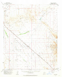
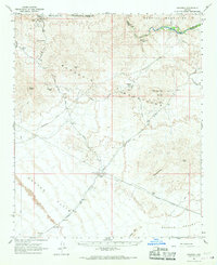
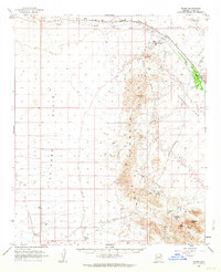 1962 Bouse1964 Print · USGSCovers Bouse, including Parker, La Paz County, and other nearby areas2 unique versions available
 - 1963 Map of Salton Sea
 1963 Salton Sea1963 Print · USGSThe Colorado Desert during the early sixties shows a landscape defined by massive water projects and Cold War military ranges. Trace the growth of Salton City and Brawley, or locate remote desert outposts like the Paymaster Mine and Desert Center.
 - 1965 Map of Salton Sea
 1965 Salton Sea1965 Print · USGSThe Colorado Desert and Imperial Valley are caught in a period of intense irrigation and military expansion during the mid-sixties. Researchers can trace the desert's industrial footprint through the Eagle Mountain Mine, the remote Desert Center, and the Salton Sea Test Base.
 - 1965 Map of Prescott
 1965 Prescott1965 Print · USGSArizona's mining heartland is captured during the mid-sixties, from the copper mines of Jerome to the cattle country of Williamson Valley Wash. Genealogists and historians can trace old mining camps at Octave and Stanton or the historic Whipple Military Reservation.
 - 1966 Map of Swansea, 1967 Print
 1966 Swansea1967 Print · USGSThe Arizona desert of the mid-sixties reveals its mining history here along the Bill Williams River. Genealogists and industrial historians can trace the Old Railroad Grade connecting Swansea and Planet, alongside a Retort Oven and local Cemeteries.2 unique versions available
 - 1969 Map of Phoenix, 1970 Print
 1969 Phoenix1970 Print · USGSCentral Arizona is seen at a technological turning point in the late sixties, using Apollo 9 space photography to map the desert landscape. Researchers can trace the growth of Sun City, locate old workings at Vulture Mine, and follow the Gila River past Buckeye.2 unique versions available
End of results
Showing maps 1-9 of 9
Top cities near Bouse
Frequently asked questions
- What are the different types of historical maps available for Bouse?
- What is the oldest map of Bouse?
- Where can I purchase historical maps of Bouse for my home or office?
- Where can I download high-res historical maps of Bouse?
- Are there historical topographic maps available for Bouse?
- Is there historical aerial imagery available for Bouse?
- Where are historical maps of Bouse sourced from?