1980s Maps of Show Low, Arizona
Explore 2 historic maps of Show Low from the 1980s. These maps offer a rare glimpse into what life looked like during the 1980s — showing old roads, neighborhoods, homes, and landmarks that have changed or disappeared over time.
Whether you're researching your family's past, planning a metal detecting trip, or studying how Show Low's landscape evolved across the 1980s, these high-resolution maps are a powerful tool for exploring the history of this region.
- Focus on a specific era: All maps on this page are from the 1980s, giving you a focused view of this time period.
- See what’s changed: Compare century-old streets, trails, and buildings to today's modern landscape using overlays and satellite layers.
- Research with precision: Use these maps for genealogy, historical research, land use analysis, or educational projects.
- View, download, or print: Maps are fully viewable online in high resolution, and can be downloaded or printed for your own records.
Start exploring Show Low's history through authentic maps from the 1980s. This is your window into the past.
Show Low, AZ maps
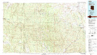
(2)- 1981 Map of Springerville, 1982 Print
 1981 Springerville1982 Print · USGSThe high-country settlements of eastern Arizona come into focus during the early eighties, from the timber towns of Lakeside and Pinetop to the ranching center of Springerville. Trace family roots in McNary and Eagar or locate historic landmarks like the Williams Creek National Fish Hatchery.2 unique versions available
 - 1981 Map of Show Low, 1982 Print
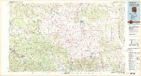
 1981 Show Low1982 Print · USGSThe Mogollon Rim highlands in the early eighties were a landscape of forest service outposts and remote reservation settlements. Local historians can trace the foundations of Show Low and Snowflake, or locate family sites near Cibecue and Heber.2 unique versions available
End of results
Showing maps 1-2 of 2
Top cities near Show Low
Frequently asked questions
- What are the different types of historical maps available for Show Low?
- What is the oldest map of Show Low?
- Where can I purchase historical maps of Show Low for my home or office?
- Where can I download high-res historical maps of Show Low?
- Are there historical topographic maps available for Show Low?
- Is there historical aerial imagery available for Show Low?
- Where are historical maps of Show Low sourced from?