1970s Maps of Show Low, Arizona
Explore 5 historic maps of Show Low from the 1970s. These maps offer a rare glimpse into what life looked like during the 1970s — showing old roads, neighborhoods, homes, and landmarks that have changed or disappeared over time.
Whether you're researching your family's past, planning a metal detecting trip, or studying how Show Low's landscape evolved across the 1970s, these high-resolution maps are a powerful tool for exploring the history of this region.
- Focus on a specific era: All maps on this page are from the 1970s, giving you a focused view of this time period.
- See what’s changed: Compare century-old streets, trails, and buildings to today's modern landscape using overlays and satellite layers.
- Research with precision: Use these maps for genealogy, historical research, land use analysis, or educational projects.
- View, download, or print: Maps are fully viewable online in high resolution, and can be downloaded or printed for your own records.
Start exploring Show Low's history through authentic maps from the 1970s. This is your window into the past.
Show Low, AZ maps
(5)- 1970 Map of Show Low North, 1973 Print
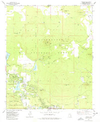
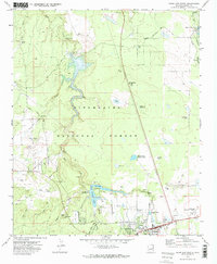 1970 Show Low North1973 Print · USGSShow Low and the surrounding high-country forests are documented here as the town expanded into a recreational and utility hub. Genealogists and historians can trace the early layout of Show Low, from the Cem and Rodeo Grounds to infrastructure like the Lone Pine Dam.2 unique versions available
 - 1971 Map of Silver Springs, 1973 Print
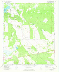 1971 Silver Springs1973 Print · USGSNavajo County's high plateau during the early seventies is defined by its vital water systems and forestry boundaries. Trace local infrastructure from the Silver Springs Fish Hatchery and White Mountain Lake to the Show Low Municipal Airport and regional Cinder Pits.3 unique versions available
 - 1976 Map of Lakeside, 1977 Print
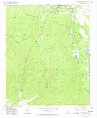
 1976 Lakeside1977 Print · USGSHigh on the Arizona plateau in the 1970s, the communities of Lakeside and Pinetop thrive alongside the Mogollon Rim. Local historians can trace family-named sites like Adair Spring and landmarks like the Springer Mtn Lookout.2 unique versions available
 - 1977 Map of Show Low South, 1978 Print
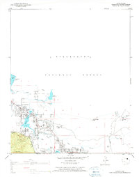
 1977 Show Low South1978 Print · USGSThe Mogollon Rim country in the late seventies shows the southern growth of Show Low as it pushes toward the reservation line. Researchers can trace historic outposts like the Forestdale Trading Post or find unnamed Ruins tucked in Forestdale Canyon.2 unique versions available
 - 1977 Map of Lakeside, 1978 Print
 1977 Lakeside1978 Print · USGSNavajo County's high-plateau communities are captured here in the late seventies as they grew along the Mogollon Rim. Local historians can trace family-named landmarks and water sources like Rainbow Lake, Adair Spring, and the Cem near the lakeside settlements.
End of results
Showing maps 1-5 of 5
Top cities near Show Low
Frequently asked questions
- What are the different types of historical maps available for Show Low?
- What is the oldest map of Show Low?
- Where can I purchase historical maps of Show Low for my home or office?
- Where can I download high-res historical maps of Show Low?
- Are there historical topographic maps available for Show Low?
- Is there historical aerial imagery available for Show Low?
- Where are historical maps of Show Low sourced from?