1990s Maps of Show Low, Arizona
Explore 4 historic maps of Show Low from the 1990s. These maps offer a rare glimpse into what life looked like during the 1990s — showing old roads, neighborhoods, homes, and landmarks that have changed or disappeared over time.
Whether you're researching your family's past, planning a metal detecting trip, or studying how Show Low's landscape evolved across the 1990s, these high-resolution maps are a powerful tool for exploring the history of this region.
- Focus on a specific era: All maps on this page are from the 1990s, giving you a focused view of this time period.
- See what’s changed: Compare century-old streets, trails, and buildings to today's modern landscape using overlays and satellite layers.
- Research with precision: Use these maps for genealogy, historical research, land use analysis, or educational projects.
- View, download, or print: Maps are fully viewable online in high resolution, and can be downloaded or printed for your own records.
Start exploring Show Low's history through authentic maps from the 1990s. This is your window into the past.
Show Low, AZ maps
(4)- 1998 Map of Show Low South, 2000 Print
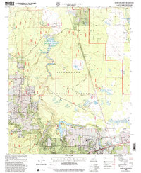
 1998 Show Low South2000 Print · USGSNavajo County's high-altitude forest and tribal lands meet at the edge of the Mogollon Rim during the late 1990s. Researchers can trace the layout of the Forestdale Trading Post, locate the NPC Campus, and explore the canyon drainages of Forestdale Creek.
 - 1998 Map of Show Low North, 2000 Print
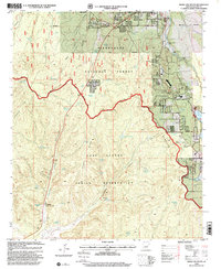
 1998 Show Low North2000 Print · USGSIn the late nineties, Show Low was expanding its footprint within the Sitgreaves National Forest. Researchers can trace local development through the Show Low Municipal Airport, neighborhood landmarks like the Rodeo Grounds, and numerous water features including Fools Hollow Lake and Long Lake.
 - 1998 Map of Silver Springs, 2000 Print
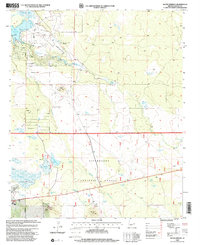 1998 Silver Springs2000 Print · USGSNavajo County and the Sitgreaves National Forest are shown here in the late nineties as a blend of forest management and growing aviation infrastructure. Researchers can locate family landmarks like Cooley Knoll or trace water resources at the Fish Hatchery and Silver Springs.
 - 1998 Map of Lakeside, 2001 Print
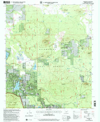 1998 Lakeside2001 Print · USGSLakeside and Pinetop are shown at the end of the twentieth century as they developed along the edge of the Apache Indian Reservation. Trace the local water and rail network through Rainbow Lake, the Sponseller Siding, and Porter Spring.
End of results
Showing maps 1-4 of 4
Top cities near Show Low
Frequently asked questions
- What are the different types of historical maps available for Show Low?
- What is the oldest map of Show Low?
- Where can I purchase historical maps of Show Low for my home or office?
- Where can I download high-res historical maps of Show Low?
- Are there historical topographic maps available for Show Low?
- Is there historical aerial imagery available for Show Low?
- Where are historical maps of Show Low sourced from?