1970s Maps of Gu Achi District, Arizona
Explore 5 historic maps of Gu Achi District from the 1970s. These maps offer a rare glimpse into what life looked like during the 1970s — showing old roads, neighborhoods, homes, and landmarks that have changed or disappeared over time.
Whether you're researching your family's past, planning a metal detecting trip, or studying how Gu Achi District's landscape evolved across the 1970s, these high-resolution maps are a powerful tool for exploring the history of this region.
- Focus on a specific era: All maps on this page are from the 1970s, giving you a focused view of this time period.
- See what’s changed: Compare century-old streets, trails, and buildings to today's modern landscape using overlays and satellite layers.
- Research with precision: Use these maps for genealogy, historical research, land use analysis, or educational projects.
- View, download, or print: Maps are fully viewable online in high resolution, and can be downloaded or printed for your own records.
Start exploring Gu Achi District's history through authentic maps from the 1970s. This is your window into the past.
Gu Achi District, AZ maps
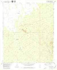
(5)- 1978 Map of Sil Nakya
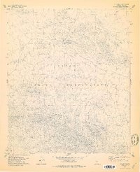 1978 Sil Nakya1978 Print · USGSThe Papago Indian Reservation in the late 1970s showcases a landscape of isolated desert settlements and vital water sources. Genealogists and historians can trace the foundations of the community through the St Agatha Mission, the local Cem, and rural outposts like Sil Nakya.
 - 1979 Map of Sil Nakya
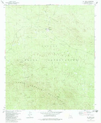 1979 Sil Nakya1979 Print · USGSThe Papago Indian Reservation is captured here in the late 1970s, focused on the high-desert terrain of the North Comobabi Mountains. Genealogists and historians can locate the St Agatha Mission, burial grounds at Cem, and desert water sources like Frog Well.
 - 1979 Map of Comobabi
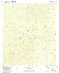 1979 Comobabi1979 Print · USGSThe Papago Indian Reservation comes into focus during the late 1970s, showcasing a landscape of desert mountains and isolated settlements. Researchers can trace the trails around Ko Vaya or locate the Emperor and Duchess Mine and local Cem.
 - 1979 Map of Ko Vaya
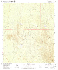 1979 Ko Vaya1979 Print · USGSThe Pima County desert landscape of the late seventies reveals a network of tribal settlements and mining history within the Papago Indian Reservation. Trace family sites and industry through the Picacho Mine, Wickchoupai (Site), and the small community of Ko Vaya.
 - 1979 Map of Sand Wells
 1979 Sand Wells1979 Print · USGSThe Papago Indian Reservation comes into focus during the late seventies, showing a landscape defined by desert water management and ranching. Researchers can trace remote sites like Sand Wells, Lorenzo, and the area around Black Mountain to locate historical wells and corrals.2 unique versions available
End of results
Showing maps 1-5 of 5
Top cities near Gu Achi District
Top neighborhoods of Gu Achi District
- San Luis historical maps
- Ko Vaya historical maps
- Palo Verde Stand historical maps
- Santa Rosa historical maps
- Maish Vaya historical maps
- Narcho Santos historical maps
See more
Frequently asked questions
- What are the different types of historical maps available for Gu Achi District?
- What is the oldest map of Gu Achi District?
- Where can I purchase historical maps of Gu Achi District for my home or office?
- Where can I download high-res historical maps of Gu Achi District?
- Are there historical topographic maps available for Gu Achi District?
- Is there historical aerial imagery available for Gu Achi District?
- Where are historical maps of Gu Achi District sourced from?