1920s Maps of Tucson, Arizona
Explore 2 historic maps of Tucson from the 1920s. These maps offer a rare glimpse into what life looked like during the 1920s — showing old roads, neighborhoods, homes, and landmarks that have changed or disappeared over time.
Whether you're researching your family's past, planning a metal detecting trip, or studying how Tucson's landscape evolved across the 1920s, these high-resolution maps are a powerful tool for exploring the history of this region.
- Focus on a specific era: All maps on this page are from the 1920s, giving you a focused view of this time period.
- See what’s changed: Compare century-old streets, trails, and buildings to today's modern landscape using overlays and satellite layers.
- Research with precision: Use these maps for genealogy, historical research, land use analysis, or educational projects.
- View, download, or print: Maps are fully viewable online in high resolution, and can be downloaded or printed for your own records.
Start exploring Tucson's history through authentic maps from the 1920s. This is your window into the past.
Tucson, AZ maps
(2)- 1925 Map of San Xavier
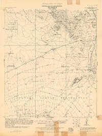 1925 San Xavier1925 Print · USGSThe Tucson area and the Papago Indian Reservation come to life in this mid-1920s survey. Researchers can trace family-named homesteads such as Kubils Ranch and Coronado Ranch alongside industrial sites like the Arizona Group Mines.
 - 1926 Map of Helvetia
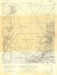 1926 Helvetia1926 Print · USGSSouthern Arizona in the mid-twenties shows a landscape of cattle ranches and high-desert outposts. Researchers can trace family-named sites like Stone's Ranch and Mc Cleary's Ranch or explore early settlements such as Helvetia and Greaterville.
End of results
Showing maps 1-2 of 2
Top cities near Tucson
- Marana historical maps
- Oro Valley historical maps
- Sahuarita historical maps
- Vail historical maps
- Corona de Tucson historical maps
- South Tucson historical maps
Top neighborhoods of Tucson
- Palo Verde Park historical maps
- Stockham historical maps
- Emery Park historical maps
- Blenman-Elm historical maps
- Jefferson Park historical maps
- Silvercroft historical maps
See more
Frequently asked questions
- What are the different types of historical maps available for Tucson?
- What is the oldest map of Tucson?
- Where can I purchase historical maps of Tucson for my home or office?
- Where can I download high-res historical maps of Tucson?
- Are there historical topographic maps available for Tucson?
- Is there historical aerial imagery available for Tucson?
- Where are historical maps of Tucson sourced from?