1940s Maps of Tucson, Arizona
Explore 3 historic maps of Tucson from the 1940s. These maps offer a rare glimpse into what life looked like during the 1940s — showing old roads, neighborhoods, homes, and landmarks that have changed or disappeared over time.
Whether you're researching your family's past, planning a metal detecting trip, or studying how Tucson's landscape evolved across the 1940s, these high-resolution maps are a powerful tool for exploring the history of this region.
- Focus on a specific era: All maps on this page are from the 1940s, giving you a focused view of this time period.
- See what’s changed: Compare century-old streets, trails, and buildings to today's modern landscape using overlays and satellite layers.
- Research with precision: Use these maps for genealogy, historical research, land use analysis, or educational projects.
- View, download, or print: Maps are fully viewable online in high resolution, and can be downloaded or printed for your own records.
Start exploring Tucson's history through authentic maps from the 1940s. This is your window into the past.
Tucson, AZ maps
(3)- 1943 Map of San Xavier Mission
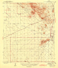 1943 San Xavier Mission1943 Print · USGSThe desert landscape southwest of Tucson was a mix of sacred sites and cattle ranches in the early 1940s. Genealogists and historians can trace the foundations of the San Xavier del Bac Mission and locate old homesteads like Triple C Ranch and Robles Well.3 unique versions available
 - 1947 Map of Cortaro
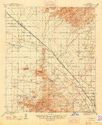 1947 Cortaro1947 Print · USGSPima County in the late 1940s showcases a desert landscape of ranching, mining, and expanding aviation infrastructure. Trace family ranching roots at Oasis Ranch or explore early aviation at the U S Army Landing Field and Silver Bell Airport.
 - 1948 Map of Tucson
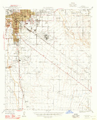 1948 Tucson1948 Print · USGSTucson and its desert surroundings are seen here in the late 1940s as the city began expanding toward its major military and aviation hubs. Genealogists and local historians can trace legacy sites like Yaqui Village, Davis-Monthan Field, and the Benedictine Convent before urban growth transformed the valley.
End of results
Showing maps 1-3 of 3
Top cities near Tucson
- Marana historical maps
- Oro Valley historical maps
- Sahuarita historical maps
- Vail historical maps
- Corona de Tucson historical maps
- South Tucson historical maps
Top neighborhoods of Tucson
- Palo Verde Park historical maps
- Stockham historical maps
- Emery Park historical maps
- Blenman-Elm historical maps
- Jefferson Park historical maps
- Silvercroft historical maps
See more
Frequently asked questions
- What are the different types of historical maps available for Tucson?
- What is the oldest map of Tucson?
- Where can I purchase historical maps of Tucson for my home or office?
- Where can I download high-res historical maps of Tucson?
- Are there historical topographic maps available for Tucson?
- Is there historical aerial imagery available for Tucson?
- Where are historical maps of Tucson sourced from?