1980s Maps of Tucson, Arizona
Explore 8 historic maps of Tucson from the 1980s. These maps offer a rare glimpse into what life looked like during the 1980s — showing old roads, neighborhoods, homes, and landmarks that have changed or disappeared over time.
Whether you're researching your family's past, planning a metal detecting trip, or studying how Tucson's landscape evolved across the 1980s, these high-resolution maps are a powerful tool for exploring the history of this region.
- Focus on a specific era: All maps on this page are from the 1980s, giving you a focused view of this time period.
- See what’s changed: Compare century-old streets, trails, and buildings to today's modern landscape using overlays and satellite layers.
- Research with precision: Use these maps for genealogy, historical research, land use analysis, or educational projects.
- View, download, or print: Maps are fully viewable online in high resolution, and can be downloaded or printed for your own records.
Start exploring Tucson's history through authentic maps from the 1980s. This is your window into the past.
Tucson, AZ maps
(8)- 1981 Map of Vail
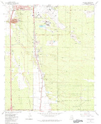
 1981 Vail1981 Print · USGSThe Rincon Valley in the early eighties shows a landscape of historic cattle ranches beginning to meet modern infrastructure. Researchers can trace the legacy of the Southern Pacific line past the Santa Rita Shrine and into the foothills near Pistol Hill.2 unique versions available
 - 1981 Map of Tanque Verde Peak
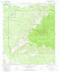 1981 Tanque Verde Peak1981 Print · USGSThe Rincon Mountains and Saguaro National Monument come alive in this early 1980s survey of the Arizona desert. Trace the historic Old Military Reservation Boundary or locate remote sites like Thunderhead Ranch and Hope Camp.4 unique versions available
 - 1981 Map of Corona De Tucson
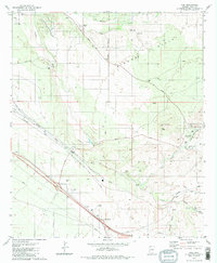
 1981 Corona De Tucson1981 Print · USGSThe high desert south of Tucson comes into focus in the early eighties as the community of Corona de Tucson began to take shape. Researchers can trace the boundaries of the Sahuarita Air Force Range and locate remote sites like Mt Fagan Ranch or the Bluejay Mine Quarry.2 unique versions available
 - 1982 Map of Tucson SE
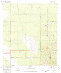
 1982 Tucson SE1982 Print · USGSSoutheastern Tucson and its desert surroundings are captured here in the early 1980s, a period of institutional expansion. Trace the rail-side growth of Wilmot and Esmond or find local landmarks like the County Fairgrounds and Corona Speedway.2 unique versions available
 - 1983 Map of Tucson
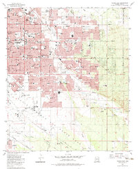
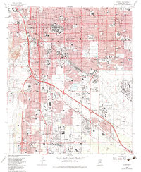 1983 Tucson1983 Print · USGSTucson and the surrounding Pima County desert appear here in the early eighties during a period of rapid suburban and infrastructure growth. Researchers can trace the footprints of established neighborhoods and sites like the University of Arizona, Pascua Yaqui Indian Village, and the expansive Davis-Monthan Air Force Base.
 - 1983 Map of Tucson SW
 1983 Tucson SW1983 Print · USGSTucson's southern edge in the early eighties reveals a landscape of aviation, industry, and tribal lands. Researchers can trace the Southern Pacific line past Martinez Hill or locate the sprawling Sahuarita Bombing and Gunnery Range.
 - 1983 Map of Tucson East
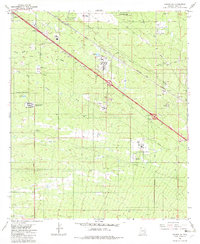
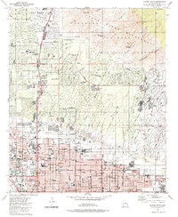
 1983 Tucson East1983 Print · USGSTucson underwent significant eastern expansion in the early eighties, as suburban neighborhoods pushed toward the desert washes. Genealogists and researchers can trace the growth of Vandenberg Village and Littletown or locate landmarks like the Pima Air Museum and Santa Rita HS.2 unique versions available
 - 1984 Map of Tucson North
 1984 Tucson North1984 Print · USGSNorth Tucson and the Catalina foothills come into focus in the mid-1980s as suburban development meets the wilderness. Researchers can trace established landmarks like Evergreen Cemetery, the Rillito Downs Race Track, and the growing neighborhoods of Casas Adobes.
End of results
Showing maps 1-8 of 8
Top cities near Tucson
- Marana historical maps
- Oro Valley historical maps
- Sahuarita historical maps
- Vail historical maps
- Corona de Tucson historical maps
- South Tucson historical maps
Top neighborhoods of Tucson
- Palo Verde Park historical maps
- Stockham historical maps
- Emery Park historical maps
- Blenman-Elm historical maps
- Jefferson Park historical maps
- Silvercroft historical maps
See more
Frequently asked questions
- What are the different types of historical maps available for Tucson?
- What is the oldest map of Tucson?
- Where can I purchase historical maps of Tucson for my home or office?
- Where can I download high-res historical maps of Tucson?
- Are there historical topographic maps available for Tucson?
- Is there historical aerial imagery available for Tucson?
- Where are historical maps of Tucson sourced from?