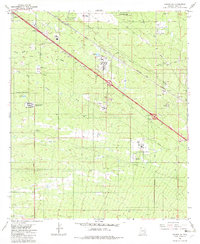
1982 Map of Tucson SE
USGS Topo · Published 1982About this map
Davis-Monthan Air Force Base anchors the northern portion of this landscape, reflecting the military and institutional development of southeastern Tucson in the early 1980s. The region is characterized by significant infrastructure, including the Federal Detention Center and the Arizona Correctional Training Facility, alongside major transportation corridors like the Southern Pacific railroad and Nogales-Vail Connection Rd.
Find a feature on this map
23 named features on this map. Tap any name to fly to it.
Don’t see what you’re looking for? This feature index may not catch every label — zoom into the map to look around manually.
Map Details
Editions of this 1982 Tucson SE Map
2 editions found
Other maps of this area

1904 · Patagonia
USGS Topo · 1:125,000

1904 · Tucson
USGS Topo · 1:125,000

1905 · Patagonia
USGS Topo · 1:125,000

1905 · Tucson
USGS Topo · 1:125,000

1926 · Helvetia
USGS Topo · 1:62,500

1948 · Tucson
USGS Topo · 1:62,500

1956 · Nogales
USGS Topo · 1:250,000

1956 · Tucson
USGS Topo · 1:250,000

1957 · Tucson East
USGS Topo · 1:24,000

1957 · Tucson
USGS Topo · 1:24,000