1940s Maps of Wickenburg, Arizona
Explore 2 historic maps of Wickenburg from the 1940s. These maps offer a rare glimpse into what life looked like during the 1940s — showing old roads, neighborhoods, homes, and landmarks that have changed or disappeared over time.
Whether you're researching your family's past, planning a metal detecting trip, or studying how Wickenburg's landscape evolved across the 1940s, these high-resolution maps are a powerful tool for exploring the history of this region.
- Focus on a specific era: All maps on this page are from the 1940s, giving you a focused view of this time period.
- See what’s changed: Compare century-old streets, trails, and buildings to today's modern landscape using overlays and satellite layers.
- Research with precision: Use these maps for genealogy, historical research, land use analysis, or educational projects.
- View, download, or print: Maps are fully viewable online in high resolution, and can be downloaded or printed for your own records.
Start exploring Wickenburg's history through authentic maps from the 1940s. This is your window into the past.
Wickenburg, AZ maps
(2)- 1947 Map of Wagoner, 1959 Print
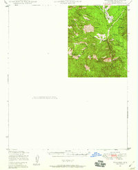 1947 Wagoner1959 Print · USGSYavapai County ranching country is captured here in the late 1940s as modern aviation began to reach remote outposts. Genealogists and historians can locate family holdings at the Diamond 2 Ranch and Cooper Ranch or trace old trails near Wagoner and Minnehaha Flat.2 unique versions available
 - 1948 Map of Wagoner
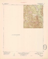 1948 Wagoner1948 Print · USGSRanching life in Yavapai County takes center stage in the late 1940s, showing a remote landscape defined by the Hassayampa River. Genealogists and historians can locate old outposts like Wagoner and Minnehaha or trace family landmarks like the Cooper Ranch.
End of results
Showing maps 1-2 of 2
Top cities near Wickenburg
- Surprise historical maps
- Buckeye historical maps
- Congress historical maps
- Circle City historical maps
- Morristown historical maps
Frequently asked questions
- What are the different types of historical maps available for Wickenburg?
- What is the oldest map of Wickenburg?
- Where can I purchase historical maps of Wickenburg for my home or office?
- Where can I download high-res historical maps of Wickenburg?
- Are there historical topographic maps available for Wickenburg?
- Is there historical aerial imagery available for Wickenburg?
- Where are historical maps of Wickenburg sourced from?