1980s Maps of Wickenburg, Arizona
Explore 2 historic maps of Wickenburg from the 1980s. These maps offer a rare glimpse into what life looked like during the 1980s — showing old roads, neighborhoods, homes, and landmarks that have changed or disappeared over time.
Whether you're researching your family's past, planning a metal detecting trip, or studying how Wickenburg's landscape evolved across the 1980s, these high-resolution maps are a powerful tool for exploring the history of this region.
- Focus on a specific era: All maps on this page are from the 1980s, giving you a focused view of this time period.
- See what’s changed: Compare century-old streets, trails, and buildings to today's modern landscape using overlays and satellite layers.
- Research with precision: Use these maps for genealogy, historical research, land use analysis, or educational projects.
- View, download, or print: Maps are fully viewable online in high resolution, and can be downloaded or printed for your own records.
Start exploring Wickenburg's history through authentic maps from the 1980s. This is your window into the past.
Wickenburg, AZ maps
(2)- 1981 Map of Bradshaw Mts, 1996 Print
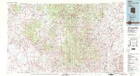 1981 Bradshaw Mts1996 Print · USGSYavapai County during the early 1980s reveals a high-desert landscape shaped by mining camps and the winding Atchison Topeka and Santa Fe railroad. Researchers can trace historic industrial sites like the Crown King Mine and remote settlements such as Bumble Bee and Cleator.2 unique versions available
 - 1988 Map of Phoenix North, 1989 Print
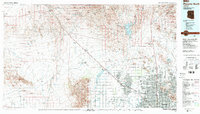 1988 Phoenix North1989 Print · USGSNorth of Phoenix in the late eighties, the desert landscape transitions from the mining heritage of Wickenburg to the burgeoning suburbs of the valley. Trace the paths of the Atchison Topeka and Santa Fe Railway or locate old operations like the Vulture Mine.2 unique versions available
End of results
Showing maps 1-2 of 2
Top cities near Wickenburg
- Surprise historical maps
- Buckeye historical maps
- Congress historical maps
- Circle City historical maps
- Morristown historical maps
Frequently asked questions
- What are the different types of historical maps available for Wickenburg?
- What is the oldest map of Wickenburg?
- Where can I purchase historical maps of Wickenburg for my home or office?
- Where can I download high-res historical maps of Wickenburg?
- Are there historical topographic maps available for Wickenburg?
- Is there historical aerial imagery available for Wickenburg?
- Where are historical maps of Wickenburg sourced from?