1950s Maps of Wickenburg, Arizona
Explore 8 historic maps of Wickenburg from the 1950s. These maps offer a rare glimpse into what life looked like during the 1950s — showing old roads, neighborhoods, homes, and landmarks that have changed or disappeared over time.
Whether you're researching your family's past, planning a metal detecting trip, or studying how Wickenburg's landscape evolved across the 1950s, these high-resolution maps are a powerful tool for exploring the history of this region.
- Focus on a specific era: All maps on this page are from the 1950s, giving you a focused view of this time period.
- See what’s changed: Compare century-old streets, trails, and buildings to today's modern landscape using overlays and satellite layers.
- Research with precision: Use these maps for genealogy, historical research, land use analysis, or educational projects.
- View, download, or print: Maps are fully viewable online in high resolution, and can be downloaded or printed for your own records.
Start exploring Wickenburg's history through authentic maps from the 1950s. This is your window into the past.
Wickenburg, AZ maps
(8)- 1950 Map of Wagoner
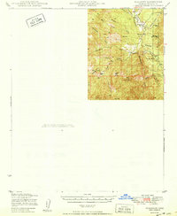 1950 Wagoner1950 Print · USGSYavapai County ranching life is preserved in this mid-century survey of the Arizona interior as it appeared just after the war. Researchers can trace the layout of the Diamond 2 Ranch, the isolated settlement of Minnehaha, and the winding course of the Hassayampa River.2 unique versions available
 - 1950 Map of Prescott, 1951 Print
 1950 Prescott1951 Print · USGSArizona's mining and ranching frontiers were in full operation during the early fifties, from the vertical streets of Jerome to the remote western desert. Genealogists and researchers can trace rural life via the Bland School, the United Verde Mine, and stops along the Atchison Topeka and Santa Fe Railway.
 - 1954 Map of Prescott, 1963 Print
 1954 Prescott1963 Print · USGSYavapai County mining and ranching districts are shown in high detail during the mid-twentieth century. Researchers can trace the legacy of remote camps and transport hubs like Swansea, Octave, and the Bagdad Mine along the desert rail lines.4 unique versions available
 - 1954 Map of Phoenix, 1964 Print
 1954 Phoenix1964 Print · USGSMid-century Arizona is captured here as the Phoenix metropolitan area begins its rapid expansion into the surrounding desert. Genealogists and historians can trace the development of agricultural hubs like Buckeye and Tolleson, or locate remote landmarks like the Vulture Mine and Nottbusch Cem.5 unique versions available
 - 1957 Map of Phoenix
 1957 Phoenix1957 Print · USGSGreater Phoenix and the central Arizona desert during the mid-fifties reveal a landscape of growing suburbs and active desert mines. Researchers can trace the legacy of local landmarks like Wickenburg Prison, the Vulture Mine, and the Tonopah Post Office.
 - 1958 Map of Prescott
 1958 Prescott1958 Print · USGSCentral Arizona's rugged mining and ranching corridors come alive in the late fifties. Genealogists and historians can trace the remote Trout Creek School, the mining operations at Jerome, and the rail stops at Skull Valley and Kirkland.
 - 1958 Map of Phoenix
 1958 Phoenix1958 Print · USGSThe Phoenix Valley enters a period of postwar expansion, where desert irrigation meets massive military aviation footprints. Trace the development of Phoenix and Glendale alongside the legendary Vulture Mine and the auxiliary runways of Luke Air Force Base.
 - 1959 Map of Prescott
 1959 Prescott1959 Print · USGSYavapai County and the central Arizona highlands come alive in the late fifties, showcasing a landscape of mountain mining towns and forest outposts. Researchers can trace the industrial footprints of the United Verde Mine, follow the Atchison Topeka and Santa Fe rails, and locate remote settlements like Swansea or Skull Valley.2 unique versions available
End of results
Showing maps 1-8 of 8
Top cities near Wickenburg
- Surprise historical maps
- Buckeye historical maps
- Congress historical maps
- Circle City historical maps
- Morristown historical maps
Frequently asked questions
- What are the different types of historical maps available for Wickenburg?
- What is the oldest map of Wickenburg?
- Where can I purchase historical maps of Wickenburg for my home or office?
- Where can I download high-res historical maps of Wickenburg?
- Are there historical topographic maps available for Wickenburg?
- Is there historical aerial imagery available for Wickenburg?
- Where are historical maps of Wickenburg sourced from?