1950s Maps of Ash Fork, Arizona
Explore 3 historic maps of Ash Fork from the 1950s. These maps offer a rare glimpse into what life looked like during the 1950s — showing old roads, neighborhoods, homes, and landmarks that have changed or disappeared over time.
Whether you're researching your family's past, planning a metal detecting trip, or studying how Ash Fork's landscape evolved across the 1950s, these high-resolution maps are a powerful tool for exploring the history of this region.
- Focus on a specific era: All maps on this page are from the 1950s, giving you a focused view of this time period.
- See what’s changed: Compare century-old streets, trails, and buildings to today's modern landscape using overlays and satellite layers.
- Research with precision: Use these maps for genealogy, historical research, land use analysis, or educational projects.
- View, download, or print: Maps are fully viewable online in high resolution, and can be downloaded or printed for your own records.
Start exploring Ash Fork's history through authentic maps from the 1950s. This is your window into the past.
Ash Fork, AZ maps
(3)- 1950 Map of Picacho Butte
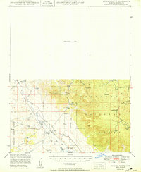 1950 Picacho Butte1950 Print · USGSYavapai County ranching and forest lands are captured here at mid-century, before modernization altered the high-desert range. Researchers can trace historic operations at the K4 Farm and CV Ranch or locate the old Stone Quarry and Mexican Dam.
 - 1954 Map of Williams, 1972 Print
 1954 Williams1972 Print · USGSThe high plateau of Northern Arizona is captured here during the mid-fifties, showing the rail-and-road corridor before the interstate era. You can trace family roots through remote railroad stops like Audley and Pica or locate early landmarks such as Grand Canyon Caverns and Frazier Wells.
 - 1956 Map of Williams, 1963 Print
 1956 Williams1963 Print · USGSNorthern Arizona in the mid-fifties reveals a landscape shaped by the Atchison Topeka and Santa Fe railroad and the iconic Highway 66. Trace the route of early travelers through Peach Springs, Seligman, and Ash Fork, or find remote sites like the Music Mountain Mine (Gold).3 unique versions available
End of results
Showing maps 1-3 of 3
Top cities near Ash Fork
Frequently asked questions
- What are the different types of historical maps available for Ash Fork?
- What is the oldest map of Ash Fork?
- Where can I purchase historical maps of Ash Fork for my home or office?
- Where can I download high-res historical maps of Ash Fork?
- Are there historical topographic maps available for Ash Fork?
- Is there historical aerial imagery available for Ash Fork?
- Where are historical maps of Ash Fork sourced from?