1970s Maps of Ash Fork, Arizona
Explore 2 historic maps of Ash Fork from the 1970s. These maps offer a rare glimpse into what life looked like during the 1970s — showing old roads, neighborhoods, homes, and landmarks that have changed or disappeared over time.
Whether you're researching your family's past, planning a metal detecting trip, or studying how Ash Fork's landscape evolved across the 1970s, these high-resolution maps are a powerful tool for exploring the history of this region.
- Focus on a specific era: All maps on this page are from the 1970s, giving you a focused view of this time period.
- See what’s changed: Compare century-old streets, trails, and buildings to today's modern landscape using overlays and satellite layers.
- Research with precision: Use these maps for genealogy, historical research, land use analysis, or educational projects.
- View, download, or print: Maps are fully viewable online in high resolution, and can be downloaded or printed for your own records.
Start exploring Ash Fork's history through authentic maps from the 1970s. This is your window into the past.
Ash Fork, AZ maps
(2)- 1973 Map of Cathedral Caves, 1976 Print
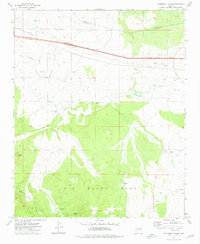 1973 Cathedral Caves1976 Print · USGSYavapai and Coconino counties are surveyed here in the early seventies, capturing a landscape of high mesas and critical water tanks. Trace the Old Railroad Grade and A T & S F lines near landmarks like Cathedral Caves and Smith Butte.
 - 1979 Map of Ash Fork
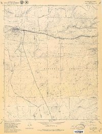 1979 Ash Fork1979 Print · USGSAsh Fork thrived as a critical railway and highway junction in the late seventies. Researchers can trace the local infrastructure and land use through the Atchison Topeka and Santa Fe line, the Cem, and numerous Cinder Pits scattered across the Kaibab National Forest.3 unique versions available
End of results
Showing maps 1-2 of 2
Top cities near Ash Fork
Frequently asked questions
- What are the different types of historical maps available for Ash Fork?
- What is the oldest map of Ash Fork?
- Where can I purchase historical maps of Ash Fork for my home or office?
- Where can I download high-res historical maps of Ash Fork?
- Are there historical topographic maps available for Ash Fork?
- Is there historical aerial imagery available for Ash Fork?
- Where are historical maps of Ash Fork sourced from?