1980s Maps of Seligman, Arizona
Explore 3 historic maps of Seligman from the 1980s. These maps offer a rare glimpse into what life looked like during the 1980s — showing old roads, neighborhoods, homes, and landmarks that have changed or disappeared over time.
Whether you're researching your family's past, planning a metal detecting trip, or studying how Seligman's landscape evolved across the 1980s, these high-resolution maps are a powerful tool for exploring the history of this region.
- Focus on a specific era: All maps on this page are from the 1980s, giving you a focused view of this time period.
- See what’s changed: Compare century-old streets, trails, and buildings to today's modern landscape using overlays and satellite layers.
- Research with precision: Use these maps for genealogy, historical research, land use analysis, or educational projects.
- View, download, or print: Maps are fully viewable online in high resolution, and can be downloaded or printed for your own records.
Start exploring Seligman's history through authentic maps from the 1980s. This is your window into the past.
Seligman, AZ maps
(3)- 1981 Map of Seligman East
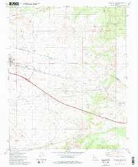 1981 Seligman East1981 Print · USGSSeligman sits at a historic crossroads in the early 1980s, where the high-desert rail economy met the interstate era. Genealogists and historians can trace the town layout near the Atchison Topeka and Santa Fe Railroad or locate local landmarks like Padre Reservoir and High Sch.2 unique versions available
 - 1981 Map of Seligman West
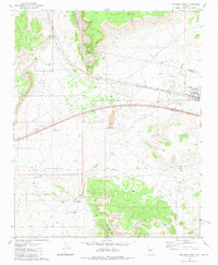 1981 Seligman West1981 Print · USGSThe high-desert crossroads at Seligman in the early 1980s reveals a landscape defined by the railroad and water management. Trace family-named landmarks like Buck Rogers Well and remote outposts such as Shorty Tank Corral along the Atchison Topeka and Santa Fe line.3 unique versions available
 - 1983 Map of Williams, 1984 Print
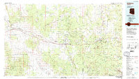 1983 Williams1984 Print · USGSThe high plateaus and ranching country of northern Arizona are captured here in the early eighties as the modern interstate era matured. Researchers can trace the rail corridor of the Atchison Topeka and Santa Fe through Ash Fork, Seligman, and the slopes of Bill Williams Mountain.3 unique versions available
End of results
Showing maps 1-3 of 3
Frequently asked questions
- What are the different types of historical maps available for Seligman?
- What is the oldest map of Seligman?
- Where can I purchase historical maps of Seligman for my home or office?
- Where can I download high-res historical maps of Seligman?
- Are there historical topographic maps available for Seligman?
- Is there historical aerial imagery available for Seligman?
- Where are historical maps of Seligman sourced from?