1960s Maps of Boone County, Arkansas
Explore 13 historic maps of Boone County from the 1960s. These maps offer a rare glimpse into what life looked like during the 1960s — showing old roads, neighborhoods, homes, and landmarks that have changed or disappeared over time.
Whether you're researching your family's past, planning a metal detecting trip, or studying how Boone County's landscape evolved across the 1960s, these high-resolution maps are a powerful tool for exploring the history of this region.
- Focus on a specific era: All maps on this page are from the 1960s, giving you a focused view of this time period.
- See what’s changed: Compare century-old streets, trails, and buildings to today's modern landscape using overlays and satellite layers.
- Research with precision: Use these maps for genealogy, historical research, land use analysis, or educational projects.
- View, download, or print: Maps are fully viewable online in high resolution, and can be downloaded or printed for your own records.
Start exploring Boone County's history through authentic maps from the 1960s. This is your window into the past.
Boone County, AR maps
(13)- 1964 Map of Harrison
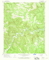
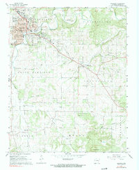
 1964 Harrison1964 Print · USGSThe Ozark and Boston Mountains of Arkansas and Missouri are captured here in the mid-sixties, showing the rugged highlands before extensive modern development. Genealogists and historians can trace family-named peaks like Gaither Mountain and follow the St Louis-San Francisco RR through Monett and Purdy.
 - 1966 Map of Omaha NE, 1968 Print
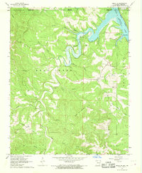 1966 Omaha NE1968 Print · USGSThe Missouri-Arkansas border region in the mid-1960s is defined by the rising waters of Bull Shoals Lake and the rugged hollows of Boone County. Genealogists and local historians can trace rural family sites like Cottonwood Cem, the settlement of Self, and old congregational hubs at Chaney Ch.2 unique versions available
 - 1967 Map of Gaither, 1968 Print
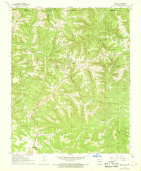
 1967 Gaither1968 Print · USGSBoone County's rugged ridges and rural hollows are captured here in the late sixties, showing the area as the local landscape transitioned. Researchers can locate numerous family burial grounds and community landmarks like Gaither Cem, Plumly Sch, and White Ch.2 unique versions available
 - 1967 Map of Bergman, 1968 Print
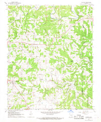
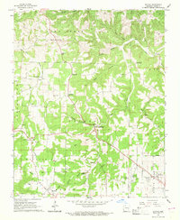
 1967 Bergman1968 Print · USGSBoone County's hill country is captured here in the late sixties as the northern edge of Harrison began to expand toward the Ozark foothills. Researchers can trace the Missouri Pacific railroad through Bergman or locate rural landmarks like York Cem and Hopewell Ch.2 unique versions available
 - 1967 Map of Jasper, 1968 Print
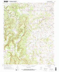
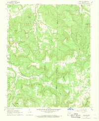
 1967 Jasper1968 Print · USGSThe Newton County backcountry comes into focus during the late sixties, centered on the riverside town of Jasper. Genealogists and historians can trace family roots at Tom Thumb Cem or explore the landscape of Dogpatch and the Buffalo National River.2 unique versions available
 - 1967 Map of Ponca, 1968 Print
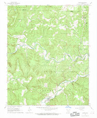
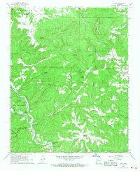
 1967 Ponca1968 Print · USGSThe Buffalo River corridor in the late sixties shows a landscape of deep hollows and high Ozark ridges. Researchers can trace rural genealogy through landmarks like Mountain Springs Cem and Plumlee Ch or locate the site of the Compton Lookout Tower.3 unique versions available
 - 1967 Map of Everton, 1968 Print
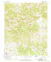
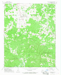
 1967 Everton1968 Print · USGSEverton and the surrounding Boone County highlands are captured here in the late sixties as traditional agriculture and rural settlements shaped the landscape. Genealogists and historians can trace numerous family burial grounds and community hubs including Rally Hill, Olvey Ch, and the Old Railroad Grade.2 unique versions available
 - 1967 Map of Hasty, 1968 Print
 1967 Hasty1968 Print · USGSThe Buffalo River valley in Newton County was still a quiet network of small settlements and river bluffs in the late sixties. Genealogists can trace family footprints at Yardelle, Wells Cem, and Collins Cem, or locate landmarks like Big Bear Cave.2 unique versions available
 - 1967 Map of Western Grove, 1968 Print
 1967 Western Grove1968 Print · USGSThe northern Arkansas Ozarks appear here in the late sixties, where the boundaries of four counties meet along the winding Buffalo River. Researchers can trace the lineage of rural communities through sites like Western Grove, the Old Railroad Grade, and several family burial grounds including Trammell Cem.2 unique versions available
 - 1967 Map of Harrison, 1968 Print
 1967 Harrison1968 Print · USGSHarrison and the surrounding Boone County highlands are captured here in the mid-1960s as the town expanded into new residential heights. Researchers can trace ancestral locations through numerous family cemeteries like Milum Cem and rural landmarks such as Krooked Kreek Ch and the Old Railroad Grade.2 unique versions available
 - 1967 Map of Omaha, 1968 Print
 1967 Omaha1968 Print · USGSOmaha and the Boone County hills are shown here during the late sixties as the railroad era continued to shape this Ozark borderland. Genealogists and local historians can locate the Burlington Lookout Tower, the cemetery at New Hope, and the path of the Missouri Pacific railroad.
 - 1967 Map of Batavia, 1969 Print
 1967 Batavia1969 Print · USGSNear the close of the 1960s, this portion of Boone County preserves a rural landscape defined by family settlements and winding creeks. Genealogists and historians can trace the legacy of old roadbeds like the Old Railroad Grade or locate family sites at Gass Cem and Liberty Ch.
 - 1968 Map of Osage NE, 1969 Print
 1968 Osage NE1969 Print · USGSIn the late sixties, this Carroll County uplands region around Delmar maintained its traditional character amidst a rugged landscape of hollows and bluffs. Researchers can find generational landmarks like Possum Trot Ch, Hilltop Cem, and the high peak of Needle Eye Mountain.2 unique versions available
End of results
Showing maps 1-13 of 13
Top cities of Boone County
- Harrison historical maps
- Diamond City historical maps
- Bellefonte historical maps
- Bergman historical maps
- Lead Hill historical maps
- Everton historical maps
See more
Frequently asked questions
- What are the different types of historical maps available for Boone County?
- What is the oldest map of Boone County?
- Where can I purchase historical maps of Boone County for my home or office?
- Where can I download high-res historical maps of Boone County?
- Are there historical topographic maps available for Boone County?
- Is there historical aerial imagery available for Boone County?
- Where are historical maps of Boone County sourced from?